
Population 2,868 (2011) | Subregion Oeste Area 15.01 km² Municipality Alcobaça, Portugal | |
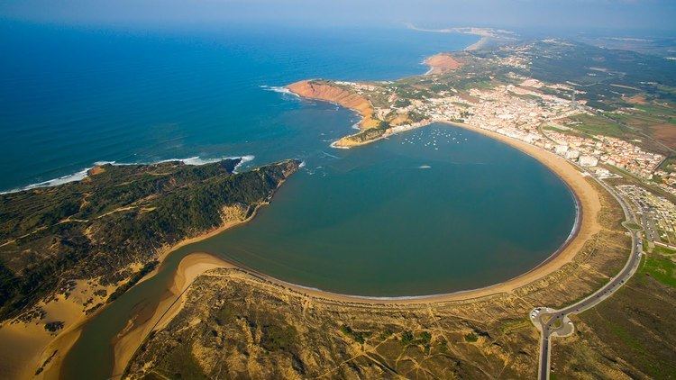 | ||
S o martinho do porto aerial 4k ultra hd
São Martinho do Porto is a freguesia (civil parish) in Alcobaça Municipality, in Oeste Subregion of Portugal. The population in 2011 was 2,868, in an area of 14.64 km². It was a town and county seat until 1855.
Contents
- S o martinho do porto aerial 4k ultra hd
- Map of SC3A3o Martinho do Porto Portugal
- Insid in s o martinho do porto
- History
- Tourism
- Heritage
- Points of interest
- References
Map of S%C3%A3o Martinho do Porto, Portugal
Insid in s o martinho do porto
History
The region constituted by the Serra da Pescaria and by the Bouro mountain constituted, in geological times, a single island. When it was divided it gave rise to the bay of São Martinho do Porto.
In historical times, the village was mentioned for the first time in a letter passed in 1257 by Friar Estevão Martins, 12th abbot of the Monastery of Alcobaça. The bay was the sea port of Alcobaça, where activities related to fishing and shipbuilding were developed. It had, in 1801, 932 inhabitants. In 1839 the parishes of Alfeizerão, Salir do Porto and Serra do Bouro were annexed. It had, in 1849, 3,596 inhabitants.
Given the local development and the construction of the pier, already around 1885 the neighborhood of the beach came to remember a second village.
It was constituted has a seaside resort frequented by the nobility and the bourgeoisie since the end of the 19th century, becoming known as the "bidet of the marquees".
Currently the village is constituted by two distinct nuclei:
Tourism
The parish has one of the most beautiful beaches in the country, a bay, shaped like a scallop, with calm waters and fine white sand. São Martinho do Porto was even considered the best beach to go with the family in the guide of 2015 beaches of eDreams. According to the online booking site for travel and hotels, the "natural bay of clear and calm water and surrounded by diverse shops and restaurants offers the ideal conditions for a relaxed family day". In addition, the company, based in Barcelona, says that "it is perfect for the baths of children, while adults relax in the sand or have a drink on a terrace overlooking the sea".
Although the commercial importance of the port has diminished, its tourist activity and the beach life give it a special dynamic, especially during the summer season.
The bay is only connected to the sea by an opening of a few meters. Hence the waters are quiet, great for children and better still for competitions of sailing, windsurf or kayak. The road by the sea, where parking is difficult, has numerous cafes, restaurants and terraces. A narrow pedestrian tunnel gives direct access to the ocean from the dock area.
In the summer of 2014, São Martinho attracted many curious people due to have been visited by a seal, probably coming from France, England or Iceland. The animal became known as "Martinha" and was, in that summer, the "mascot" of the village.