
- summer (DST) CEST (UTC+2) Local time Tuesday 7:27 AM | Area 20.41 km² | |
 | ||
Weather 7°C, Wind NW at 6 km/h, 98% Humidity University Sazava Theological Seminary Points of interest Sázava Monastery, Centrum sklářského umění - H, Ve Studeném, Český svaz ochránců přírody S | ||
Sázava ( [ˈsaːzava]) is a town in the Central Bohemian Region of the Czech Republic. It lies between Tábor and Prague on a bend on a river. It has around 3,800 inhabitants.
Map of 285 06 S%C3%A1zava, Czechia
Villages Bělokozly, Černé Budy, Čeřenice and Dojetřice are administrative parts of Sázava.
Originally a monastery with Slavic liturgy, originated in 1032. Since the early 12th century the Benedictine monastery. Burnt down by the Hussites, revived in the 16th century, in the 17th century rebuilt in the Baroque style. The monastery abolished by Joseph II, in the 19th century rebuilt into a Pseudo-Renaissance chateau. A monumental torso of the Church of St. Prokop, an abbot chapel, a Gothic crypt. The exposition “the Old-Slavic Sázava”, a capitulary hall with Gothic wall paintings. A significant medieval centre of Slavic culture and literature. The Madonna of Sázava stands in the main church which remains operational.
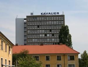
The eastern side of the town is very different in character and is largely industrial in character.