
Named for William Russell Area 733 km² Population 17,752 (2013) | Founded 1826 | |
 | ||
Website www.russellcountyky.com Points of interest Lake Cumberland, Wolf Creek Dam, Russell Springs City Park, Lakewood Golf Course | ||
Russell County is a county located in the U.S. Commonwealth of Kentucky. As of the 2010 census, the population was 17,565. Its county seat is Jamestown. The county was formed on December 14, 1825 from portions of Adair, Cumberland and Wayne Counties and is named for William Russell. It has been a prohibition or dry county, meaning that the sale of alcohol was prohibited, but in a referendum on Jan. 19, 2016, the county voted 3,833 to 3,423 to go "wet."
Contents
- Map of Russell County KY USA
- Geography
- Major highways
- Adjacent counties
- Demographics
- Politics
- Communities
- References
Map of Russell County, KY, USA
In 2015, the cities of Jamestown and Russell Springs became two of the first gigabit Internet communities in Kentucky with the completion of a state-of-the-art optical fiber network by the local telephone cooperative.
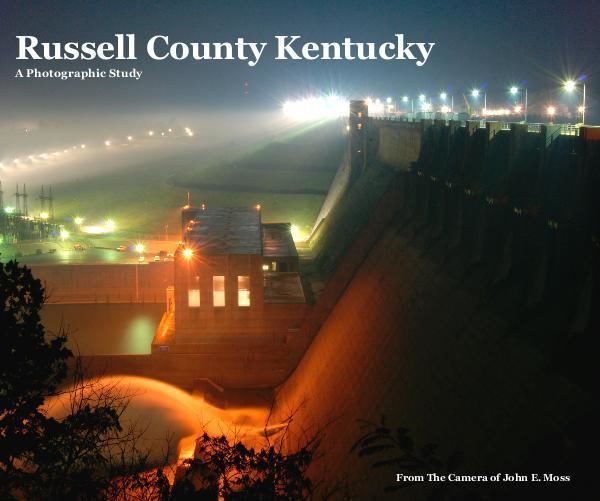
Wolf Creek Dam is located in southern Russell County. The dam impounds Cumberland River to form Lake Cumberland, a major tourism attraction for the county. Wolf Creek National Fish Hatchery is also located in Russell County just below the dam.
Geography
According to the U.S. Census Bureau, the county has a total area of 283 square miles (730 km2), of which 254 square miles (660 km2) is land and 29 square miles (75 km2) (10%) is water. The highest point is 1,140 feet (350 m) atop Dickerson Ridge in the extreme northern part of the county and the lowest point is 530 feet (160 m) along the Cumberland River.
Major highways
Adjacent counties
Demographics
As of the census of 2000, there were 16,315 people, 6,941 households, and 4,796 families residing in the county. The population density was 64 per square mile (25/km2). There were 9,064 housing units at an average density of 36 per square mile (14/km2). The racial makeup of the county was 98.34% White, 0.58% Black or African American, 0.12% Native American, 0.14% Asian, 0.02% Pacific Islander, 0.21% from other races, and 0.59% from two or more races. 0.86% of the population were Hispanic or Latino of any race.
There were 6,941 households out of which 29.00% had children under the age of 18 living with them, 55.30% were married couples living together, 10.20% had a female householder with no husband present, and 30.90% were non-families. 28.00% of all households were made up of individuals and 12.90% had someone living alone who was 65 years of age or older. The average household size was 2.33 and the average family size was 2.82.
In the county, the population was spread out with 22.50% under the age of 18, 7.50% from 18 to 24, 27.50% from 25 to 44, 25.90% from 45 to 64, and 16.50% who were 65 years of age or older. The median age was 40 years. For every 100 females there were 93.90 males. For every 100 females age 18 and over, there were 91.00 males.
The median income for a household in the county was $22,042, and the median income for a family was $27,803. Males had a median income of $24,193 versus $18,289 for females. The per capita income for the county was $13,183. About 20.40% of families and 24.30% of the population were below the poverty line, including 30.80% of those under age 18 and 27.30% of those age 65 or over.
Politics
Russell County is part of the historically and currently rock-ribbed Republican bloc of southeastern Kentucky that also includes such counties as Clinton, Cumberland, Casey, Pulaski, Laurel, Rockcastle, Monroe, McCreary, Clay, Jackson, Owsley and Leslie. These counties were opposed to secession during the Civil War era, and consequently became and have remained intensely Republican ever since. The last Democrat to win Russell County was Grover Cleveland in 1884, and the last Republican to not gain a majority was William Howard Taft in 1912 when his party was divided.