
- left Dang He, Beida He Length 630 km Source elevation 3,650 m Country China | - location Qilian Shan, Gansu Basin area 78,600 km² Mouth Badain Jaran Playa Cities Zhangye | |
 | ||
- location Badain Jaran Desert, Inner Mongolia Sources Kan Chou Spring, Hsü Chao Spring | ||
Ruo Shui (Chinese: 弱水, literally: "weak water", also Etsin Gol or Ruo He or Ejin River) is a major river system of northern China. It flows approximately 630 kilometres (390 mi) from its headwaters on the northern Gansu side of the Qilian Mountains north-northeast into the endorheic Ejin Basin in the Gobi Desert. The river forms one of the largest inland deltas or alluvial fans in the world. Its drainage basin covers about 78,600 square kilometres (30,300 sq mi) in parts of the Chinese provinces of Gansu and Inner Mongolia.
Contents
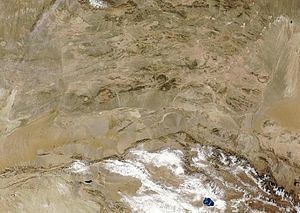
Map of Ruoshui River, China
Geography
The river rises as the Heishui (黑水, black water) on the north slopes of the Qilian Mountains roughly 75 kilometres (47 mi) southeast of Minle. It flows north then northwest past Zhangye, picking up several tributaries from the south. For the first 150 kilometres (93 mi) its water is used to irrigate fields along its valley. It then turns north-northeast, flowing out into the desert, and becoming a losing stream as its water sinks into the surrounding earth. This quality is what gives the river its name, as it greatly lessens the flow and even causes it to dry up in some years. From the turn it runs about 175 kilometres (109 mi) in that direction onto a vast alluvial plain formed by the river's sediment deposits. This part of the river is also known as the Etsin Gol or Etsin River. At Ximiao, the river splits into two ephemeral distributaries called the Dong He (東河, eastern river) and the Xi He (西河, western river), each about 220 kilometres (140 mi) long, draining into the Juyan Lake Basin. The Dong empties into a lake called Sogo Nur, while the Xi river empties into a seasonal basin called the Gaxun Nur.
Delta
The Ruo River has created over the past few million years one of the largest inland river deltas or alluvial fans in the world. Sediments deposited by the river span across a massive area 300 kilometres (190 mi) long and 200 kilometres (120 mi) across. The delta is crossed by hundreds of dry channels entrenched by the river during its frequent course changes. Because the climate of the area has followed a drying trend over the past 10,000 years or so, the delta is no longer considered active (i.e. deposits are not being built up significantly) and is slowly being eroded by wind and water action.
Desertification
The river area has been suffering from acute desertification. Ground water levels have dropped by as much as 5 metres (16 ft) since the 1940s, while forest coverage near the river shrunk by 1,924 km2 (743 sq mi) between 1958 and 1994 and the Juyanhai Lake, once covering 1,200 km2 (460 sq mi), has dried up entirely.
History
About 2,000 years ago, the river was said to have a much more abundant flow than it does today and thus its perennial reaches stretched much farther out into the desert than it does today. Parts of the river flow through the Hexi Corridor, a valley which once formed a significant portion of the Silk Road. The upper section of the river (also known as the Heihe River) was first settled by the Chinese in about 100 B.C. Many outposts were created to protect Silk Road traders from the frequent attacks of barbarians, as the water-abundant valley of the river in relation with the aridity of the surrounding terrain provided an easy route for Huns and Mongols to launch raids. Since then, the river valley has been intensely cultivated and logged. However, clearing of the landscape has caused increased erosion, leading to desertification of the region and a gradual reduction of the river flow.
The lower part of the river was once confused to be the middle reach of the Yellow River, which lies farther east but flows for a significant distance in the same direction paralleling the Ruo River.
The former Tangut city of Khara-Khoto, now deserted, lies near the lower end of the river. According to legend, the city was abandoned after Ming forces diverted the river away from the city in 1372.
European explorers to visit the area include Pyotr Kuzmich Kozlov (1907–1909) and John DeFrancis (1935).
In the 20th century, China's main space port, the Jiuquan Satellite Launch Center was constructed in the lower course of the Ruo Shui, with launch pads on both sides of the river.