
Area rank 104 of 105 Lowest elevation 287 m (942 ft) Area 29.49 km² Lau 2 10012 | Canton Esch-sur-Alzette Highest elevation 432 m (1,417 ft) Time zone CET (UTC+1) Local time Friday 5:45 PM Team US Rumelange | |
 | ||
Weather 12°C, Wind NE at 18 km/h, 64% Humidity | ||
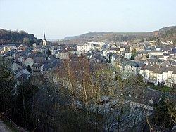
Rumelange (Luxembourgish: Rëmeleng [ˈʀəməleŋ], German: Rümelingen) is a commune with town status in south-western Luxembourg, on the border with France. As of the February 1, 2011 census, the commune had a population of 5,038.
Map of Rumelange, Luxembourg
As of 2008, the town of Rumelange, which lies in the east of the commune, has a population of 4,818.
Rumelange was formed on 25 September 1891, when it was detached from the commune of Kayl. The law forming Rumelange was passed on the 27 June 1891.
It is the site of some of the underground iron mines no longer in operation. Rumelange is home to Luxembourg's National Mining Museum.
References
Rumelange Wikipedia(Text) CC BY-SA