
Area rank 81st of 105 Lowest elevation 274 m (899 ft) Area 14.86 km² Lau 2 10006 | Canton Esch-sur-Alzette Highest elevation 425 m (1,394 ft) Time zone CET (UTC+1) Local time Saturday 11:34 AM | |
 | ||
Weather 10°C, Wind E at 8 km/h, 55% Humidity | ||
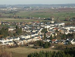
Kayl (Luxembourgish: Keel) is a commune and town in south-western Luxembourg. It is part of the canton of Esch-sur-Alzette, which is part of the district of Luxembourg.
Map of Kayl, Luxembourg
As of 2001, the town of Kayl, which lies in the centre of the commune, has a population of 4,237. Other towns within the commune include Tétange.
The first surviving written reference to 'Keyle' dates from 1235. Since the thirteenth century the name of the town has not changed significantly, although more than twenty different spellings have been identified.
References
Kayl Wikipedia(Text) CC BY-SA