
Area 70.73 km² | Time zone +8 Population 40,922 (Jan 2016) | |
 | ||
Country Republic of China (Taiwan) | ||
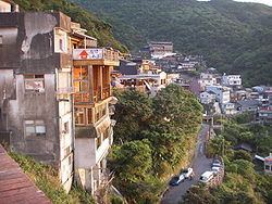
Ruifang District (Chinese: 瑞芳區; Hanyu Pinyin: Ruìfāng Qū; Tongyong Pinyin: Rueìfang Cyu; Pe̍h-ōe-jī: Sūi-hong-khu) is a suburban district in eastern New Taipei City, Taiwan.
Contents
- Map of Ruifang District New Taipei City Taiwan 224
- History
- Administrative divisions
- Tourist attractions
- Transportation
- References
Map of Ruifang District, New Taipei City, Taiwan 224
History
During the period of Japanese rule, Ruifang was called Zuihō Town (瑞芳街), and was governed under Kīrun District (基隆郡) of Taihoku Prefecture. Mining was an important industry in Ruifang (then known as Sui-hong) in the early 20th century. Gold was mined in Kyufun and Kinkaseki while coal was mined in Kau-tong (猴硐; Houtong).
The mining sites became popular tourist destinations after 1990. In March 2012, it was named one of the Top 10 Small Tourist Towns by the Tourism Bureau.
Administrative divisions
Longtan, Longxing, Longzeng, Longan, Longchuan, Longshan, Zhaofeng, Xinfeng, Tunghe, Ganping, Gongqiao, Houtong, Guangfu, Shuoren, Jiqing, Jian, Shangtian, Jieyu, Jishan, Yongqing, Chongwen, Fuzhu, Songde, Guashan, Tongshan, Xinshan, Shishan, Liandong, Lianxin, Nanya, Bitou, Haibin, Ruibin and Shenao Village.
Tourist attractions
Transportation
Ruifang is served by the Yilan Line of the Taiwan Railway Administration. There are four stations in Ruifang Township: Ruifang Station, Houtong Station, Sijiaoting Station and Sandiaoling Station.
Provincial Highway No. 62 passes Ruifen and will provide convenient connection to Keelung City when it is completed.