
Length 600 km Bridges Mkapa Bridge | ||
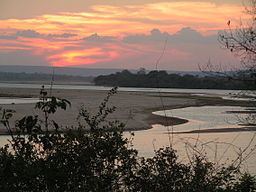 | ||
The mighty rufiji river
The Rufiji River lies entirely within Tanzania. The river is formed by the confluence of the Kilombero and Luwegu rivers. It is approximately 600 kilometres (370 mi) long, with its source in southwestern Tanzania and its mouth on the Indian Ocean at a point between Mafia Island called Mafia Channel. Its principal tributary is the Great Ruaha River. It is navigable for about 100 kilometres (62 mi).
Contents
- The mighty rufiji river
- Map of Rufiji River Tanzania
- Rufiji river infected mushroom muse breaks wmv
- History
- Basin
- References
Map of Rufiji River, Tanzania
The Rufiji is about 200 kilometres (120 mi) south of Dar es Salaam. The river's delta contains the largest mangrove forest in eastern Africa.
Rufiji river infected mushroom muse breaks wmv
History
A branch of ancient sea routes led down the East African coast called "Azania" by the Greeks and Romans in the 1st century CE as described in the Periplus of the Erythraean Sea (and, very probably, 澤散 Zesan in the 3rd century by the Chinese), at least as far as the port known to the Romans as Rhapta, which was probably located in the delta of the Rufiji River in modern Tanzania.
During the First World War, from October 1914 to July 1915, the river delta was the scene of a protracted naval operation. These were the attempts, and later achievement, by the Royal Navy to neutralize and destroy the German cruiser Konigsberg.
Basin
The catchment basin for the Rufiji River complex is 177,429 square kilometres (68,506 sq mi).