
Parent range Sierra Nevada Easiest route Scramble, class 3 First ascent 1946 Mountain range Sierra Nevada | Topo map USGS Mount Abbot Elevation 4,020 m Prominence 179 m | |
 | ||
First ascenders Virgina Whitacre, Fritz Gerstaker Similar Mount Mills, Mount Abbot, Mount Morgan, Bear Creek Spire, Red Slate Mountain | ||
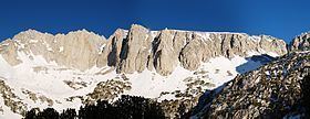
Ruby Peak is a thirteener on the Sierra Crest, north of Mount Mills. It is in the John Muir Wilderness and on the boundary between the Sierra National Forest and the Inyo National Forest. The eastern slope drains into Rock Creek which feeds the Owens River while the western slopes drains in Mono Creek which feeds the South Fork of the San Joaquin River.
Contents
Map of Ruby Peak, California 93634, USA
ClimbingEdit
The first ascent was on July 24, 1946 by Fritz Gerstaker and Virginia Whitacre by the class 3, west couloir route. A grade IV, class 5.11 route, known as Technical Knockout, ascends Ruby Wall and features a large roof. It was first climbed by Richard Leversee, Kim Miller and Roanne Miller in July 1989.
References
Ruby Peak (California) Wikipedia(Text) CC BY-SA