
Population 1,044 (2011 Census) | Civil parish Roxwell Sovereign state United Kingdom Post town City of Chelmsford | |
 | ||
Roxwell is a village and civil parish in the Chelmsford District of Essex England. The village is approximately 4 miles (6 km) west from the centre of the county town of Chelmsford, and to the south of the A1060 road, on which is the hamlet of Boyton Cross.
Contents
- Map of Roxwell Chelmsford UK
- The Village
- History
- Population
- Occupational History
- Health in the village
- References
Map of Roxwell, Chelmsford, UK
The Village
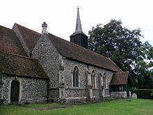
The Anglican parish church of St Michael and All Angels dates from the 14th century and is a Grade II* listed building.
There are not a lot of public facilities located in this village. There is a primary school called Roxwell Church of England Voluntary Controlled Primary School which is linked to the local Anglican parish church, The Chequers public house, and a village store/post office.
Roxwell Church of England Voluntary Controlled Primary School is only a small school having only 86 pupils as of 2015. In the most recent Ofsted report that occurred in September 2014, the primary school had an overall rating of 'Good'. The Church of England school has historically had lower Ofsted ratings of only 'satisfactory', but since 2010 the school has improved and therefore so have the reports. This has been positive change for the whole village as it has meant that standards in local education have improved which makes this village more desirable.
The original Roxwell cricket club disbanded in 2004 when membership fell to an unsustainable level. In July and August 2004 the ground was used by Havering Blues team for its last three home games in the T Rippon Mid Essex League. The Blues have played at Stonehill Road since that time and from 2006 adopted the name Roxwell Blues.
History
In 1870-72, Roxwell was described as:
"a parish, with a village, in Chelmsford district, Essex; on the river Chelmer, 4½ miles W by N of Chelmsford r. station."
In 1894, the village had a parish council consisting of 7 members and a chairman. Also, at this time the village had a manor house called Dukes Manor which belonged to Lord Petre.
This ordnance survey map shows the settlement in the 20th century. From looking at this map, it is clear that Roxwell at this time was a very small village and parish with few features distinguishable from the map.
Population
According to the 2011 census, Roxwell had a population of 1,044, and 23.2% of this population are between 45 and 59 years old. The ethnic make up of the area is predominantly white, making up 93.9% of the population in this area (English, Welsh, Scottish or Northern Irish). The rest of the population is made up of White Irish, White Gypsy or Irish Traveller, White Other, Mixed Ethnic Group - White and Asian, Mixed Ethnic Group - Other, Asian/Asian British- Indian, Asian/Asian British - Pakistani, Asian/Asian British - Other Asian, Black/African/Caribbean/Black British - African, Other Ethnic Group - Arab, and Other Ethnic Group - Any Other Ethnic Group.
Overall, Roxwell's population has grown over the last 200 years. From 1800, population was gradually increasing. For 50 years it increased with few fluctuations, but then started to decrease. Eventually population was back at the same level as it was in 1800 of around 650 people in this area. However, after this point, population slowly started to increase and then following the end of the Second World War in 1946 there was a baby boom. This meant that population reached its peak around 1960 at just over 1200 people, but then declined rapidly. However, looking at the data from all previous census' dating back to 1800, and specifically at the 2011 census, it is continuing to grow at a steady ready rate of just over 1000 people.
Occupational History
From looking at the following occupational structure graphs, there has been a clear change in fields of employment since 1881. In 1881 agriculture was the dominant field of occupation whereas in 2011, most of the residents, approximately 16%, worked in professional occupations. You can see a clear change in the occupational structure for men who have shifted from Agricultural occupations to occupations involved in Construction. Nowadays, few women work in the Domestic Offices or Services, whilst the majority of women work in Social Services such as in Human Health or Education. This changing pattern of occupation fits in with the overall national trends, where 12% of those in England and Wales work in Skilled Trades Occupations.
Health in the village
Results from the 2011 census show that 46.8% of Roxwell's population were of very good health and only 0.4% of the total population were of very poor health. The statistic regarding if day-to-day activities are limited also supports the overall good health of the population of Roxwell. This is because 877 of the 1044 population were not limited in day-to-day life, as of 2011. Overall, the village occupants are of good health and do not majorly rely upon their local healthcare.