
Existed: 1969 – present DE 54 DE 58 → Length 67.33 km | Tourist
routes: Blue Crab Scenic Byway MD 54 MD 55 → Constructed 1969 | |
 | ||
West end: MD 313 in Mardela Springs, MD East end: DE 1 in Fenwick Island, DE Counties Wicomico County, Maryland (MD), Sussex County, Delaware (DE) | ||
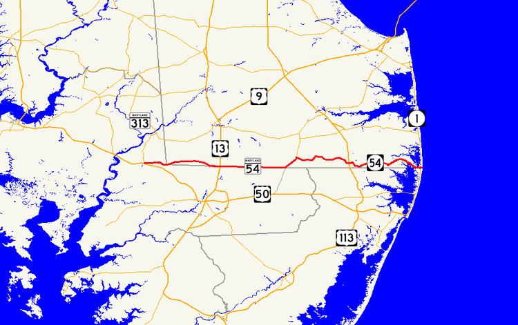
Delaware Route 54 (DE 54) and Maryland Route 54 (MD 54) are adjoining state highways in the U.S. states of Delaware and Maryland. Route 54 runs 41.84 mi (67.33 km) from MD 313 in Mardela Springs, Maryland east to DE 1 in Fenwick Island, Delaware. In addition to two segments in which the highway is completely in Delaware and two segments in which the highway is completely in Maryland, Route 54 follows the Delaware/Maryland state line between the twin towns of Delmar, Maryland and Delmar, Delaware and the highway's intersection with MD 353 and DE 26. One section of the state line portion of Route 54 is maintained by the Delaware Department of Transportation (DelDOT) while three sections of the highway that follow the state line are maintained by the Maryland State Highway Administration (MDSHA).
Contents
- Map of DE 54 Delaware USA
- Route description
- History
- Major intersections
- Delaware Route 54 Alternate
- References
Map of DE-54, Delaware, USA
Route 54 was first numbered in two segments in Wicomico County, Maryland in the late 1930s. MD 467 was assigned to the segment around Mardela Springs while MD 455 was assigned to the state line road near Delmar. The Delaware portions of the highway remained unnumbered until the late 1960s, when DelDOT briefly assigned DE 32 to the highway along the southern edge of Sussex County before designating it DE 54. The Maryland State Roads Commission (now MDSHA) immediately reciprocated by designating its portions MD 54. Route 54 east of Selbyville has become an important route for seasonal beach traffic headed to and from Fenwick Island and Ocean City, with suburban development lining the road between DE 20 and the eastern terminus. DelDOT has signed DE 54 Alternate (DE 54 Alt.) as an alternate route to the beaches. Improvements have been made to the route west of Fenwick Island, including building a causeway to reduce flooding and adding a center left-turn lane.
Route description
Route 54 begins at an intersection with MD 313 in Mardela Springs in Wicomico County, Maryland. MD 313 heads north from the intersection as Sharptown Road and west as a short continuation of Delmar Road west to MD 313's terminus with U.S. Route 50 (US 50) (Ocean Gateway). Route 54 heads east as two-lane undivided Delmar Road, paralleling Barren Creek on the north toward the Delaware state line. After passing the stone marker indicating the intersection of the Transpeninsular Line with the southern end of the Mason–Dixon Line, the highway enters the southwest corner of Sussex County, Delaware, where it intersects Columbia Road. Route 54 continues east until Old Racetrack Road, where the highway turns southeast toward the state line. At the intersection with Waller Road, the state highway begins to follow the state line, with Sussex County, Delaware on the north side of the road and Wicomico County, Maryland on the south, and MDSHA maintenance begins. Route 54 immediately enters the twin towns of Delmar, Delaware and Delmar, Maryland and the highway's name changes to State Street. The highway crosses Norfolk Southern Railway's Delmarva Secondary track south of Highball Signal and meets MD 675 (Bi State Boulevard), the old alignment of US 13, in the center of the towns. Route 54 continues east to modern US 13, which is known as Sussex Highway in Delaware and Ocean Highway in Maryland. At US 13, the highway leaves Delmar and DelDOT assumes maintenance for the highway.
Route 54 continues east from US 13 as Line Road through farmland and scattered residences along the state line. At Brittingham Road, maintenance jurisdiction returns to MDSHA. Around the intersection with Whitesville Road, Route 54 dips into Maryland for a short distance, then returns to following the state line until the intersection with MD 353 (Gumboro Road) and DE 26 (Millsboro Highway). At that intersection, Route 54 turns northeast and joins DE 26 in a concurrency. From this point, the highway remains in Delaware. A short distance north of the state line, DE 30 (Whitesville Road) joins the concurrency. In Gumboro, DE 26 and DE 30 continue north while Route 54 turns east onto Cypress Road. Route 54 crosses Bald Cypress Branch and the Pocomoke River, then passes through the Great Cypress Swamp. After crossing the swamp, the highway intersects US 113 on the west edge of Selbyville.
Route 54 continues east into Selbyville as Cemetery Road and crosses the Snow Hill Line of the Maryland and Delaware Railroad. The highway turns south into Main Street to pass through the central business district. After intersecting the southern terminus of DE 17 (Bethany Road), Route 54 turns east onto Lighthouse Road. In the hamlet of Bunting, the highway intersects DE 54 Alt. (Bunting Road), an alternate route from Selbyville to Bethany Beach. Route 54 begins to pass beach-related suburban development as the highway intersects the east end of DE 20 (Zion Church Road). Past this intersection, the route gains a center left-turn lane and continues past more development. As the highway approaches Fenwick Island, it becomes two lanes again and crosses two tidal ponds on an elevated causeway before it crosses The Ditch between Assawoman Bay to the south and Little Assawoman Bay to the north. After passing to the north of the Fenwick Island Light, Route 54 reaches its eastern terminus at DE 1 (Coastal Highway) in Fenwick Island, one block west of the Atlantic Ocean and one block north of Ocean City on the other side of the state line.
Route 54 has an annual average daily traffic count ranging from a high of 14,866 vehicles at the Old Stage Road intersection in Delmar to a low of 1,464 vehicles at the Parker Road intersection west of Selbyville. None of Route 54 is part of the National Highway System.
History
By 1920, what is now Route 54 in Delaware existed as an unpaved county road. The portion of the current route along Millsboro Highway was proposed as a state highway by 1925. This segment of state highway was completed by 1931, along with the portions from south of Columbia to a point along the state line to the east of Delmar and between Selbyville and Williamsville. A portion of the route along the state line east of Delmar was paved as a county road. On July 1, 1935, the county-maintained portions of the road in Delaware were taken over by the state. By 1936, the roadway was paved between Williamsville and Fenwick Island. A portion of road to the west of Selbyville was paved by 1939. By 1942, the remainder of the road in Delaware between the Maryland border and south of Columbia and Gumboro and Selbyville were paved.
The first non-concurrent portions of Route 54 to be numbered were in Maryland in 1939, when MD 467 was marked on the portion around Mardela Springs and MD 455 was marked on the portion around Delmar, which extended from where Waller Road fully enters Maryland east to Brittingham Road. The portion of road between Brittingham Road and MD 353 was county-maintained. MD 455 was extended east from Brittingham Road to DE 26 in 1958. In 1968, DE 32 was assigned to the entire highway within Delaware; the Maryland sections were still marked as MD 467 and MD 455. The whole highway was marked as Route 54 in 1969. In addition to the concurrencies with DE 26 and DE 30, Route 54 has been concurrent with DE 20. DE 20 was extended east of Dagsboro to terminate in Fenwick Island along with Route 54 by 1994. DE 20's eastern terminus was rolled back to its present location in 2005. Despite this, some DE 20 shields are posted along DE 54 between that route's eastern terminus and Fenwick Island. In September 2001, construction began to build an elevated causeway for Route 54 to the west of Fenwick Island in order to prevent flooding from high tides and storms. The project involved building the new causeway to the north of the original alignment, using pre-cast concrete segments. The project, which cost over $15 million, was slated to be finished in August 2003. In 2010, a $10 million project began to add a center left-turn lane along with bike lanes and sidewalks to the portion of Route 54 between DE 20 and Mallard Lakes, a section of road that was targeted for safety improvements due to rapid development; this project was completed in 2012.
Major intersections
DE 54 officially has a length of 38.59 mi (62.10 km) and MD 54 officially has a length of 19.79 mi (31.85 km). Both of these figures include a 16.54 mi (26.62 km) overlap between the first and last crossings of the state line.
Delaware Route 54 Alternate
Delaware Route 54 Alternate (DE 54 Alt.) is an alternate route of DE 54 between Bunting and DE 26 in Bethany Beach. The alternate route heads northeast from DE 54 on two-lane undivided Johnson Road, passing through a mix of farmland and woodland. Upon crossing DE 20, DE 54 Alt. continues north along Bayard Road through more rural areas, passing through the community of Bayard. The route turns east onto Double Bridges Road and continues northeast through forested areas along with a few residential subdivisions. DE 54 Alt. turns east onto Kent Avenue and crosses the Assawoman Canal, where it curves north and passes residential development before ending at DE 26 at Bethany Beach. DE 54 Alt. was designated by 2006.
Major intersections
The entire route is in Sussex County.