
- elevation 3,130 ft (954 m) | Area 13 ha | |
 | ||
Similar Patagonia Lake State Park, Dead Horse Ranch St, Buckskin Mountain State Park, Fool Hollow Lake, Becker Lake | ||
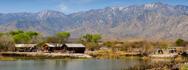
Roper Lake State Park is a state park of Arizona, surrounding 32-acre (130,000 m2) Roper Lake. The park is located off U.S. Route 191, 5 miles (8.0 km) south of Safford, at the Gila River and Valley.
Contents
Map of Roper Lake, Arizona 85546, USA
The land for the park, formerly a ranch, was purchased by the state in 1972 in order to construct a reservoir.
Roper Lake State Park includes a boat ramp, a natural stone hot tub, a beach for swimming, a picnic area, a campground, and cabins. The lake is stocked with bass and trout, and boats are limited to small electric motors. Hiking trails are available, and the park is an excellent place for birdwatching. This scenic park in southeast Arizona is in a beautiful location surrounded by the sky island Pinaleño Mountains range, including Mount Graham.
In another part of the park is Dankworth Pond, located about 3 miles (4.8 km) south. This 15-acre (61,000 m2) pond also offers fishing, a picnic area, and hiking trails.