
Population 232 (2011 census) | Postcode(s) 4343 Postal code 4343 | |
 | ||
Ropeley is a locality in the Lockyer Valley Region, Queensland, Australia. At the 2011 census, Ropeley had a population of 232 people.
Contents
Map of Ropeley QLD 4343, Australia
History
The Deep Gully Provisional School opened in 1890 and in 1892 was renamed Ropeley Provisional School. On 2 Sep 1901 it became Ropeley State School. The school celebrated its centenary in 1990.
Education
Ropeley State School is a co-educational government primary school located at 4 Hodger Road, Ropeley. In 2013, the school had 11 enrolled students with two teaching staff (one equivalent full-time). In 2015, only one child was enrolled.
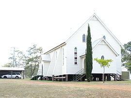
The Ropeley Immanuel Lutheran Church was officially opened on Sunday 4 February 1923 with a crowd of approximately 1,200 people. The opening of the church brought together two previously separate Lutheran congregations in the district.
Facilities
Reflecting its German heritage, Ropeley has one church, the Ropeley Immanuel Lutheran Church.
Ropeley has two cemeteries: