
Country United States Elevation 1,553 m Population 6,750 (2013) | Founded 1905 Time zone Mountain (MST) (UTC-7) Zip code 84066 | |
 | ||
Weather 10°C, Wind W at 6 km/h, 62% Humidity University Uintah Basin Applied Technology College | ||
Roosevelt utah oil fields mov
Roosevelt is a city in Duchesne County, Utah, United States. The population was 6,046 at the 2010 census, with an estimated population of 6,777 in 2014.
Contents
- Roosevelt utah oil fields mov
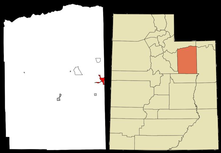
- Map of Roosevelt UT 84066 USA
- Geography
- Demographics
- History
- Economy
- Education
- Religion and local culture
- Notable residents
- References
Map of Roosevelt, UT 84066, USA
The proper pronunciation of the city's name /ˈroʊzəvɛlt/ is based on how President Theodore Roosevelt pronounced his name: according to the man himself, "pronounced as if it was spelled 'Rosavelt.'"
Geography
The city is on the eastern edge of Duchesne County, adjacent to the border with Uintah County. The town of Ballard borders Roosevelt to the east. U.S. Routes 40 and 191 pass through Roosevelt as Main Street, leading east 30 miles (48 km) to Vernal and west 28 miles (45 km) to Duchesne.
According to the United States Census Bureau, the city of Roosevelt has a total area of 5.6 square miles (14.4 km2), all of it land.
Demographics
As of the census of 2000, there were 4,299 people, 1,380 households, and 1,095 families residing in the city. The population density was 818.6 people per square mile (316.2/km²). There were 1,566 housing units at an average density of 298.2 per square mile (115.2/km²). The racial makeup of the city was 86.58% White American, 0.19% Black or African American, 8.14% Native American, 0.21% Asian American, none Pacific Islander American, 1.74% from other races, and 3.14% from two or more races. Hispanic or Latino of any race were 3.88% of the population.
There were 1,380 households out of which 51.0% had children under the age of 18 living with them, 60.8% were married couples living together, 14.2% had a female householder with no husband present, and 20.6% were non-families. 16.7% of all households were made up of individuals and 5.9% had someone living alone who was 65 years of age or older. The average household size was 3.12 and the average family size was 3.51.
In the city, the population was spread out with 39.5% under the age of 18, 10.7% from 18 to 24, 25.4% from 25 to 44, 16.1% from 45 to 64, and 8.3% who were 65 years of age or older. The median age was 25 years. For every 100 females there were 94.0 males. For every 100 females age 18 and over, there were 88.4 males.
The median income for a household in the city was $29,190, and the median income for a family was $32,328. Males had a median income of $32,117 versus $18,043 for females. The per capita income for the city was $11,945. About 19.2% of families and 22.1% of the population were below the poverty line, including 26.7% of those under age 18 and 10.1% of those age 65 or over.
History
In 1905, by an act of Congress, the unallotted land of the Ute Indian Reservation was opened to homesteading. Several thousand hopeful 20th-century pioneers congregated in Provo and Grand Junction with the hope of successfully drawing lots for a homestead in a fertile region of the soon-to-be-opened lands. Throughout the fall and winter of 1905-06 the settlers came to the Uinta Basin.
The town of Roosevelt was founded in early 1906 when Ed Harmston turned his homestead claim into a townsite and laid out plots. His wife named the prospective town in honor of the president of the United States, Theodore Roosevelt. Roosevelt was originally called "Dry Gulch City", taking its name from a nearby gulch which only carries water during the early spring runoff season. Within a short time a store, a post office, and the Dry Gulch Irrigation Company were in business in the new town. In 1907, the Harmstons donated 2 acres (8,100 m2) of ground for the town's citizens to build a school. The first class had about fifteen pupils, who had to provide books from their homes. Roosevelt soon became the economic center for the area, eclipsing Myton and Duchesne.
Roosevelt is situated on U.S. Route 40 in the northeast corner of the state, south of the Uinta Mountains, at an elevation of 5,250 feet (1,600 m). The town was incorporated at a mass meeting of 44 citizens on 21 February 1913. From 1906 to 1914 Roosevelt was in Wasatch County, but in 1914 Duchesne County was formed from part of Wasatch County, and, as the largest town in the county, Roosevelt anticipated becoming the county seat. However, when the total county-wide vote came in, the seat went to Duchesne.
Economy
The population of Roosevelt is approximately 6,700 people, but the town serves as the business center for several times that number from the many small towns and farming communities in the area.
Roosevelt is located in an area of vast oil reserves spanning the northeast corner of Utah and extending into western Colorado. The town "booms" whenever oil prices go up and falls on harder times when oil prices decrease. The proposed Uinta Basin Rail project would build a new railroad line into Roosevelt for transporting oil drilled in the area.
The city used to have an oil refinery, "Plateau", named for the geographic location of the area, the Colorado Plateau. The oil from this area is known as "Uinta Basin Black Wax Crude" and has to be refined differently than most types of oil. Those in the oil business and land owners who profit from oil shares indicated during the high oil prices of 2005–2006 that refineries were cutting their profits by limiting the amount of Uinta Basin Black Wax they would refine.
Various types of farming, including beef cattle, sheep, pigs, horses, honey and hay, are prevalent in the outlying areas around town.
Roosevelt is also home of the only hospital in the county, Uintah Basin Medical Center.
Education
Roosevelt has become the county's educational center with Union High School, Uintah Basin Applied Technology College, and Utah State University's Uintah Basin Regional Campus all located there. Union High School is on the east end of town and straddles the border between Duchesne and Uintah Counties, thus the name "Union".
Roosevelt is part of the Duchesne School District. Other schools in the area include: Eagle View Elementary (Public/K-8), East Elementary School (Public/K-2), Kings Peak Elementary (Public/3-5), Roosevelt Middle School (Public/4-6), Roosevelt Junior High School (Public/6-8), and Thompsen School (Public/3-12).
Religion and local culture
The Church of Jesus Christ of Latter-day Saints is the dominant religious denomination in Roosevelt, with three stakes centers in town; the community also includes Roman Catholic, Christian Assembly of God, Baptist, Jehovah's Witnesses, and other smaller denomination congregations.
Located near the Uintah/Ouray Indian Reservation headquarters of Fort Duchesne, Roosevelt is a multicultural and polyethnic community, with Caucasians and Native Americans being the most numerous. Roosevelt is situated in lands designated as the Uintah and Ouray Indian Reservation and there are many Pow-Wows and Indian Ceremonies held throughout the summer and falls months.
The UBIC (Uintah Basin in Celebration) is Roosevelt's annual celebration. What started in the early part of the century as a yearly display of the latest in farming and industrial technology has developed into a yearly gala complete with parade, talent show, concerts, and dances.