
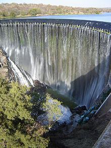
Official name Roodeplaat Dam Opening date 1959 Height 55 m Catchment area 684 km² | Opened 1959 Construction began 1955 | |
 | ||
Owner Department of Water and Sanitation Similar Roodeplaat Nature Reserve, Bon Accord Dam, Rietvlei Dam, Rietvlei Nature Reserve, Roodekoppies Dam | ||
Lumphunters carp fishing south africa large waters roodeplaat dam
Roodeplaat Dam is a concrete arch dam situated in South Africa on the Pienaars River (also known along parts of its length as the Moretele River and Moreleta Spruit), a tributary of the Crocodile River (Limpopo), which flows northwards into the Limpopo River. The dam is a warm monomictic impoundment with stable thermal stratification during the summer.
Contents
- Lumphunters carp fishing south africa large waters roodeplaat dam
- Map of Roodeplaat Dam South Africa
- Fishing mar leo roodeplaat dam june 2016
- Use
- Water quality
- References
Map of Roodeplaat Dam, South Africa
Fishing mar leo roodeplaat dam june 2016
Use
Roodeplaat Dam was originally an irrigation dam, and soon became popular for recreation. Later it became an important source for Magalies Water, a state-owned water board that supplies potable water to a large area north of Pretoria. The hazard potential of the dam has been ranked high.
Water quality
Roodeplaat Dam's catchment contains a large part of the rapidly expanding : municipality of Tshwane, which includes Pretoria. Two sewage treatment works feed treated effluent to the dam, resulting in highly eutrophic conditions comparable with those experienced in Hartbeespoort Dam. These conditions were already apparent in the mid 1970s and have not improved. Consequences of eutrophication include blooms of algae and cyanobacteria, and dense mats of water hyacinth (Eichhornia crassipes).
The Department of Water Affairs' Resource Quality Information Services directorate is housed on the banks of Roodeplaat Dam, near the wall. This section is responsible for national monitoring of the surface water resources of South Africa.