
Country Brazil Population 1.749 million (Jul 1, 2014) University Universidade Federal de Rondonia Area 237,576.16 km2 | Capital Porto Velho Governor Confucio Moura | |
Destinations Porto Velho, Ariquemes, Vilhena, Ji-Parana, Cacoal | ||
Rondonia is a state in Brazil, located in the north-western part of the country. To the west is a short border with the state of Acre, to the north is the state of Amazonas, in the east is Mato Grosso, and in the south is Bolivia. Its capital is Porto Velho. The state was named after Candido Rondon.
Contents
- Map of Rondonia
- Demographics
- Native Brazilians
- Infrastructure
- Expovel 2010 abertura rodeio e fogos pvh rondonia by claudio dantas
- Geography
- References
Map of Rondonia
Demographics
According to the IBGE of 2008, there were 1,519,000 people residing in the state. The population density was 6.6 inh./km². Urbanization: 66.8% (2004); Population growth: 2.2% (1991-2000); Houses: 430,747 (2005).
The last PNAD (National Research for Sample of Domiciles) census revealed the following numbers: 832,000 Brown (Multiracial) people (54.81%), 546,000 White people (35.95%), 115,000 Black people (7.56%), 16,000 Asian people (1.08%), 8,000 Amerindian people (0.53%).
Native Brazilians
As of 2011 there were 21 Indigenous Territories in Rondonia, with two more in process of being demarcated. The largest of these, the Uru-Eu-Wau-Wau Indigenous Territory, covers over 1.8 million hectares. Another, the Rio Omere Indigenous Territory, is home to the Kanoe and Akuntsu people. Both tribes were the victims of massacres by cattle ranchers in the 1970s and 1980s and currently number just four and five individuals respectively.
Infrastructure
Belmonte Airport is located in the state capital of Porto Velho.
Cai nAgua Port is connecting Porto Velho to Humaita, Manicore and Manaus.
Expovel 2010 abertura rodeio e fogos pvh rondonia by claudio dantas
Geography
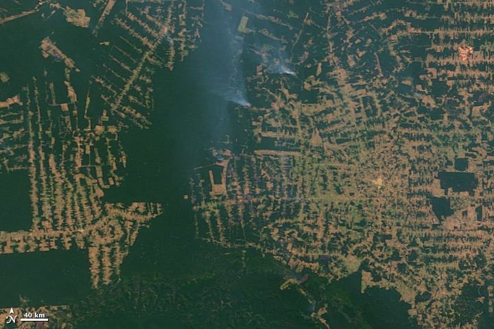
Rondonia was originally home to over 200,000 km2 of rainforest, but has become one of the most deforested places in the Amazon. By 2003 around 70,000 km2 of rainforest had been cleared.
The area around the Guapore River is part of the Beni savanna ecoregion.
The Samuel Dam is located in the state, on the Jamari River.