
Topo map OS Landranger 3 Elevation 450 m Listing Marilyn | OS grid HU305835 Designated 11 August 1997 Prominence 450 m | |
 | ||
Translation stony ground or scree (Norse) Similar Ward Hill - Hoy, Merrick, Cheeks Hill, Kirriereoch Hill, Ebrington Hill | ||
Ronas Hill (or Rönies Hill) (450m) is a Marilyn, the highest point of Mainland, Shetland, in Scotland. There is a Neolithic chambered cairn near the summit.
Contents
Map of Ronas Hill, Shetland, UK
Location
Ronas Hill (Old Norse: rön, meaning stony ground or scree) is on the Northmavine peninsula of Mainland, Shetland, at HU305835. The Norse name certainly describes the hilltop. It is the highest point on the entire Shetland archipelago. On a clear day, much of Shetland can be seen from the summit. It looks over Yell Sound, the North Sea, across to the Atlantic Ocean and even the highest points of Fair Isle.
Botany
Ronas Hill is a Ramsar site, containing many rare Arctic plants. Peculiarly for Shetland, there are several species of woodland fungi, notably ceps and chanterelles, which normally grow on the roots of deciduous trees (notable by their absence on Ronas Hill). Here, they are associated with creeping willow, which grows extensively on the hill.
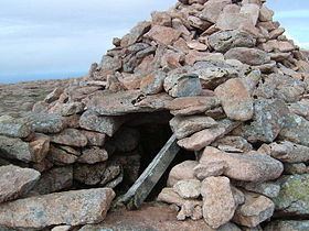
Chambered cairn
On top of the hill, there is a Neolithic chambered cairn, unusual for its position on top of a hill. Most surviving Neolithic British cairns are sited in prominent places, but not generally on the top of taller hills. According to local farmers, until the construction of Sullom Voe Terminal in the mid-1970s, the cairn contained a variety of "sacrifice" items, such as coins (some "very old") and other items. Before that time, Ronas Hill would have been far off the beaten track.
Ronas Hill cairn shows evidence of substantial rebuilding of its upper structure, as evidenced by the lack of lichen on stones above the entry passage and main cyst. The current peak of pink granite stones is clearly visible from the valley below and may have been raised in height to serve as a "mede" or fishing mark in past centuries. The cairn was certainly altered by soldiers during a military exercise in the 1960s, when a wall was built around its entrance to turn it into a foxhole.