
 | ||
Roman umbria top 6 facts
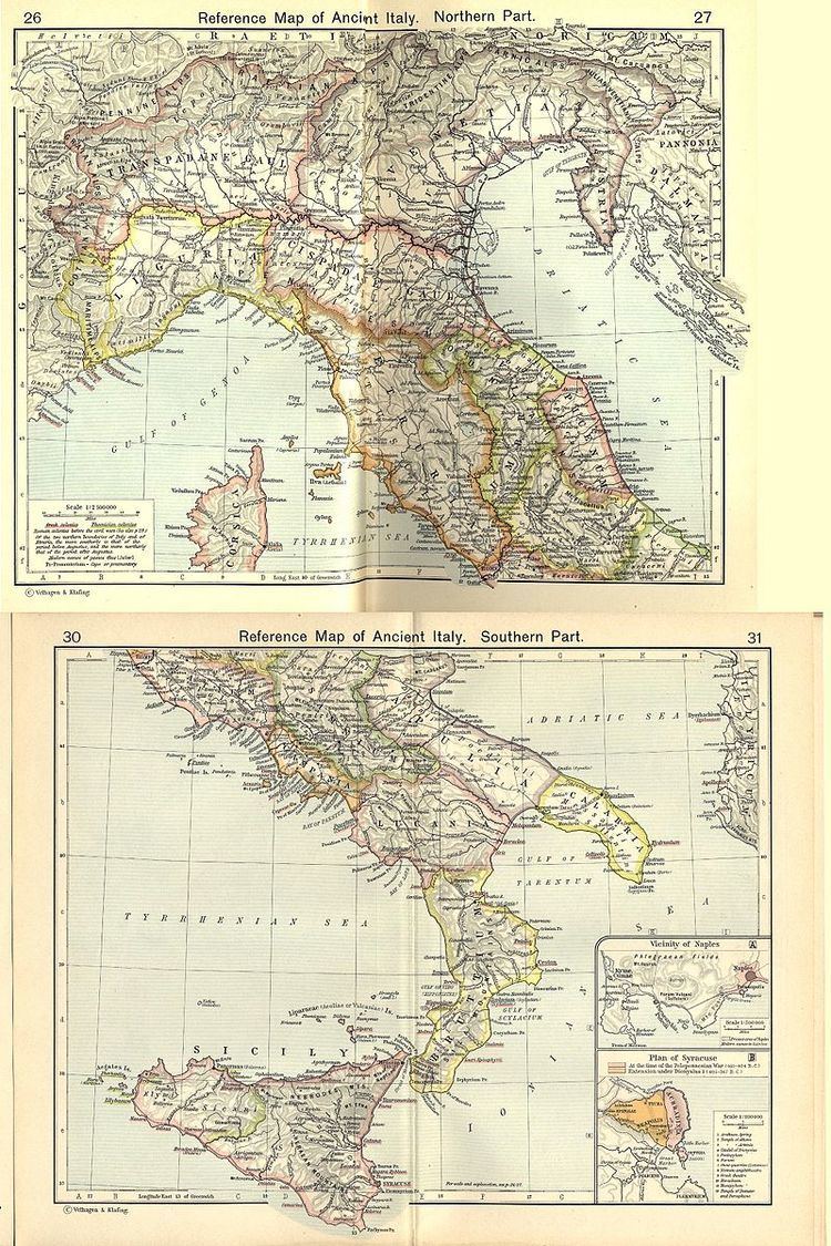
Roman Umbria is a modern name for one of the 11 administrative regions into which the emperor Augustus divided Italy. The main source for the regions is the Historia Naturalis of Pliny the Elder, who informs his readers he is basing the geography of Italy on the discriptio Italiae, "division of Italy," made by Augustus. The Sexta Regio ("6th Region") is called Umbria complexa agrumque Gallicam citra Ariminium, "Umbria including the Gallic country this side of Rimini."
Contents
- Roman umbria top 6 facts
- Italic Umbria
- Umbria in the geographers of the empire
- Pliny
- Gallia togata
- Umbria proper
- Ptolemy
- Gallia Togata
- References
Umbria is named after a proto-Italic people, the Umbri, who were gradually subjugated by the Romans in the 4th through the 2nd centuries BC. Although it passed the name on to the modern region of Umbria, the two coincide only partially. Roman Umbria extended from Narni in the South, northeastward to the neighborhood of Ravenna on the Adriatic coast, thus including a large part of central Italy that now belongs to the Marche; at the same time, it excluded the Sabine country (generally speaking, the area around modern Norcia) and the right bank of the Tiber, which formed part of Roman Etruria: for example Perusia (the modern Perugia) was not part of Roman Umbria; and Sarsina, the birthplace of Plautus, is regularly stated to have been "in Umbria" — which it was, but is not now: Sarsina is in the modern province of Forlì, in Emilia-Romagna.
The importance of Umbria in Roman and medieval times was intimately bound up with the Via Flaminia, the consular road that supplied Rome and served as a military highway into and out of the City: for this reason once the Roman empire collapsed, Umbria became a strategic battleground fought over by the Church, the Lombards and the Byzantines, and suffered consequently, becoming partitioned among them and disappearing from history. The modern use of "Umbria" is due to a renaissance of local identity in the 17th century.
Italic Umbria
Before its defeat by and assimilation to the Romans, Umbria was a sovereign state populated by a people speaking the Umbrian language. This circumstance prevailed in history during the early and middle Roman Republic. By the late republic, Umbria was part of Rome. The language was no longer generally spoken.
Umbria in the geographers of the empire
Like any other region, over the centuries Region VI changed its borders. These changes are reflected in the writings of the imperial geographers.
Pliny
The sexta regio is described in some detail by Pliny the Elder.
Gallia togata
Gallia Togata went along the northern Adriatic coast of Italy in Marche from Ancona to "this side of Rimini." The southernmost point of Gallia Togata is Ancona. He mentions the Aesis River (Esino) north of there, Senagallia (Sinigaglia), Pisaurum (Pesaro) and then Fanum (Fano) at the mouth of the Metaurus (Metauro) River.
There follows a folk-etymologic statement concerning the name of the Umbri. People believe, he says, that they are named from the thunderstorms (imbres) of the deluge and therefore that they are the oldest people on Earth. (The ancient Greeks and Romans inherited a mythological tradition of a deluge independent of that of the Old testament.) Some of his further statements appear to be equivocal, leading to some historical misidentification of Gallia Togata. He declares:
"The largest part of this district was occupied by Sicilians and Liburnians especially the territories of Palma, Praetutia and Adria."
This Adria (Hadrianus) is Atri, Italy on the coast of Abruzzi south of Ancona. Praetutia is Interamnia Praetutia, capital city of the Petrutii. From Interamnea comes Teramo and from Praetutia comes Aprutium, later Abruzzo. The coast of Abruzzo was in Augustus' Region IV; however, Pliny does not say that the Abruzzo was the largest part of Gallia Togata, only that it was the largest part of the region settled by Sicilians and Liburnians. Similarly if Hadrianus is taken to be Adria in Veneto then Gallia Togata would appear to be a synonym for all Gallia Cisalpina. However, Veneto is not "this side of Rimini."
Pliny states his belief that the Umbrians once held the north Adriatic coast, displacing Sicilians and Liburnians, and were in turn displaced by the Etruscans. The Gauls expelled them. Romans colonized the Gallic coast to control it, hence "togata."
Umbria proper
For Umbria proper Pliny simply lists the settlements: Spello, Todi, Amelia, Attiglio, Assisi, Arna, Iesi, Camerino, Casuentillum, Carsulae, Dolates Sallentini, Foligno, Market of Flaminius, Market of Julius, Market Brenta, Fossombrone, Gubbio, Terni, etc.
Ptolemy
Ptolemy, 2nd century geographer, does not lump Gallia Togata together with Umbria, but describes them as separate regions.
Gallia Togata
In Ptolemy, Ancona is in Picenum. The strip of country "above" the Apennines, "extending as far as Ravenna," is Gallia Togata. Thirteen towns are listed for it, which are south of the Po River, but are as far inland as Piacenza. This region is somewhat larger than the one of the same name in Augustus' time, comprising almost all of Emilia-Romagna. The towns are: Piacenza, Fidenza, Brescello, Parma, etc.
Umbria proper
For the Umbri Ptolemy has only nine towns, omitting some of the major ones: Arna, Spello, Todi, etc.