
Work begun 28 June 2010 Operating speed Width 10 m Route Leh–Manali Highway | Traffic Motor vehicles Length 8,800 m Road Leh–Manali Highway Operator Border Roads Organisation | |
 | ||
Location Himachal Pradesh, India No. of lanes Two (one in each direction) | ||
Rohtang Tunnel is a tunnel being built under the Rohtang Pass in the eastern Pir Panjal range of the Himalayas on the Leh-Manali Highway. With 8.8 km (5.5 mi) length, the tunnel will be one of the longest road tunnel in India (the longest road tunnel in India is the Chenani-Nashri Tunnel or Patnitop tunnel north of Udhampur) and is expected to reduce the distance between Manali and Keylong by about 60 km (37.3 mi) The tunnel is at 3,100 metres (10,171 ft) elevation whereas the Rohtang pass is at 3,978 metres (13,051 ft) elevation 51 km (32 mi) away from Manali. The pass receives heavy snowfall and blizzards during winter months and is open for road traffic for only four months in a year. Lying on the Manali-Leh axis, this is one of the two routes to Ladakh. The other route through the Zoji La pass on the Srinagar-Drass-Kargil-Leh highway also gets blocked by snow for nearly four months in a year. These two routes are vital to feed military supplies into the sub-sector west (facing Aksai Chin) and the Siachen Glacier.
Contents
- Map of Rohtang Tunnel Burwa Himachal Pradesh 175103
- Location
- Status of progress of the project
- Expected completion
- Challenges
- Specifications
- Safety measures
- Trivia
- References
Map of Rohtang Tunnel, Burwa, Himachal Pradesh 175103
First time the Moravian Mission in 1860 has talked about the possibility of a tunnel through Rohtang Pass to reach Lahaul and later Pandit Nehru talked about a rope way to Rohtang Pass which again made a point of discussion among the local tribes. After almost 139 years of the first instance, when a childhood friend of a Lahaul resident Mr. Arjun Gopal became Prime Minister of India as Shri Atal Bihari Bajpai, the locals insisted Arjun Gopal to meet the Prime Minister and talk about Rohtang Tunnel. Then he moves with two of his companions Chhering Dorje and Abhay Chand to Delhi and after continuous discussions of about one year, finally Prime Minister Atal Bihari Bajpai agreed and visited headquarter of Lahaul in year 2000 June and declared the construction of Rohtang Tunnel.
Location
Rohtang tunnel is not exactly under Rohtang pass; it is slightly west of the pass. The southern end (portal) of the tunnel is reached by turning left at Palchan, 10 km north of Manali on the way to Rohtang pass or about 40 km before Rohtang pass. After crossing Solang village, Dhundi is reached after 10 km. The south end of the tunnel is just north of Dhundi across the [[Bhaga River]Tributary of Chenab River]] at 32.3642° North and 77.1330° East coordinates.
The northern end of the tunnel meets the existing Manali-Leh highway near Teling village at 32.4388° North and 77.1642° East coordinates about 10 km west of Gramphu which is the first village after Rohtang Pass on the existing highway.
Rohtang tunnel was planned for ensuring an all-weather road route to strategically important areas of Ladakh and providing round-the-year connectivity to the remote Lahaul-Spiti valley. However, the construction of Rohtang tunnel will provide all-weather connectivity only to the Lahaul Valley of Himachal Pradesh up to Kyelang (Keylong). The all-weather road to Ladakh will require more tunnels: either at Shikunla, or at the passes located on the present Leh-Manali road for a year-round road connectivity to Ladakh.
The project was conceived in 1983 and announced by Prime Minister Atal Bihari Vajpayee on 3 June 2000. The project was estimated to cost Indian rupee ₹ 5 billion and be completed in seven years. On 6 May 2002, the Border Roads Organization was entrusted with the construction of the tunnel, and on 23 May 2002, the work was inaugurated by Mr. Vajpayee. The cost of the project was revised to ₹13.35 billion, with an expected completion by 2010.
However the work did not progress much, with the project not moving beyond the tree-felling stage by May 2003. By December 2004, the project cost estimate had escalated to ₹17 billion In May 2007, the contract was awarded to SMEC (Snowy Mountains Engineering Corporation) International Private Limited, an Australian company, and the completion date was revised to 2014. Despite multiple announcements that the work on the tunnel would begin in 2008, no progress had been made by November 2009.
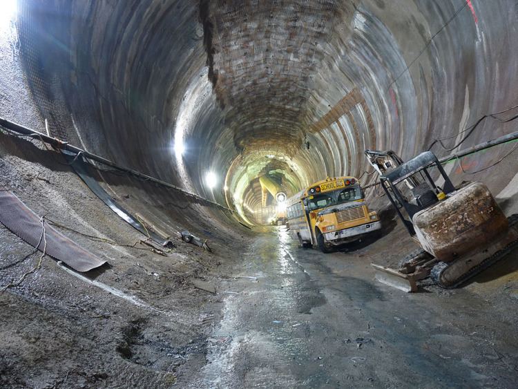
The work was awarded to a joint venture of AFCONS Infrastructure Limited, an Indian construction company of Shapoorji Pallonji Group, and STRABAG AG, Austria in September 2009 after the Cabinet Committee on Security cleared the Rohtang Tunnel Project. The drilling of the Rohtang Tunnel through the Himalayan ranges began on 28 June 2010 at South Portal 30 km (19 mi) north of Manali.
Status of progress of the project
Expected completion
The Border Roads Organisation (BRO), a tri-service Defence Ministry agency specialising in road and bridge construction in difficult terrains, had initially estimated that the tunnel would be ready for vehicle flow by 2015. The date of completion now has been pushed back to August 2019.
Challenges
The most challenging task is to continue the excavation during heavy snowfall in winter. Excavation for tunnelling is being done from both ends. However, as Rohtang pass closes during the winter, the north portal is not accessible during winter and the excavation is being done only from the south portal. Only about one-fourth of the entire tunnel will be excavated from the north end and three-fourths will be excavated from the south end. There are more than 46 avalanche sites on approaches to the tunnel.
Other challenges to the progress of the tunnel include difficulties in disposing more than 800,000 m³ of excavated rock and soil and heavy ingress of water (as much as 3 million litres per day in June 2012) from unstable rocks that slows the blasting and digging, requires constant 24x7 dewatering and costlier treatment and slowed the progress of excavation from 5 metre per day to just half a metre a day. A cloud-burst and flash flood on 8 August 2003 killed 42 labourers who were building the temporary access road. Questions were also raised on the impact of cutting down more than 700 trees on the ecology.
Specifications
The tunnel is intended to create an all-weather route to Leh and Lahaul and Spiti valleys in Himachal Pradesh. A feasibility study for the construction of a tunnel across Rohtang Pass was conducted by RITES.
Salient features of the proposed Rohtang Tunnel are as follows:
The following parameters have been set in design:
Project Cost : Approximately Rs.(INR)17 billion (Euro 250 million)
Safety measures
A 2.25 m high and 3.6 m wide emergency tunnel will be integrated in the tunnel cross-section beneath the main carriageway for evacuation during emergencies.
The latest Austrian tunnelling method and ventilation system — semi transverse type considered as safest — will be adopted for this project. Heavy snowfall in the Rohtang Pass area is a major concern, especially on the approach roads to the main tunnel. To prevent any damage to the roads and to ensure the safety of the roads and tunnel users alike, avalanche control structures are being constructed. The design for these structures is being provided by the Snow and Avalanche Study Establishment of DRDO.
As the Rohtang tunnel will witness heavy traffic, vehicular management and checking pollution is a priority. For this, CCTV cameras would be placed at a regular distance and will be further connected to two monitoring rooms on both ends of the tunnel. Sensors to check the pollution level will keep on updating the data and if the record is above the desired level, then quantity of fresh air injected inside the tunnel would be increased. Pollution level will be controlled within 90 seconds adding that two heavy duty fans each on both openings of the tunnel will be installed to inject fresh air inside.
The tunnel will have semi-transverse ventilation system, where large fans would separately circulate air throughout the tunnel length. Another safety feature being added is that fire inside the tunnel will be controlled within an area of 200 metres and fire hydrants will be provided on specific locations.
The tunnel will also have public announcement system to make important announcement in emergency situations for which loudspeakers will be installed at regular distances.