
Country United States County Burlington Named for Charles Roebling Area 3.036 km² | Elevation 43 ft (13 m) Zip code 08554 | |
 | ||
Weather 6°C, Wind W at 6 km/h, 57% Humidity Restaurants Bob's Corner Deli, Dr Lou's Place ‑ Live Musi, Mario and Franks, Glory Days Tavern, Florence FOP Lodge 210 | ||
Roebling is an unincorporated community and census-designated place (CDP) located within Florence Township, in Burlington County, New Jersey, United States, that was established as part of the 2010 United States Census. As of the 2000 United States Census, the CDP was combined as Florence-Roebling, which had a total population of 8,200. As of the 2010 Census, the Florence-Roebling CDP was split into its components, Florence (with a population of 4,426) and Roebling. As of the 2010 Census, the population of the Florence CDP was 4,426.
Contents
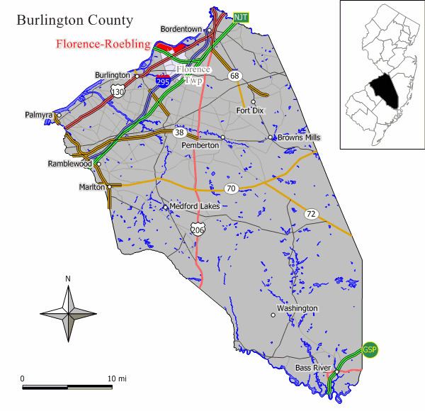
Map of Roebling, Falls Township, NJ, USA
History
Roebling, site of the Roebling Steel Mill, was founded by Charles Roebling, son of John A. Roebling. John A. Roebling & Sons company built and provided the steel for the Brooklyn Bridge, the Golden Gate Bridge, as well as numerous other bridges including one over Niagara Falls.
The steel mill was also responsible for the production of the elevator cables for the Empire State Building in New York City, the Chicago Board of Trade Building in Chicago and the Washington Monument in Washington, D.C. John A. Roebling & Sons company made the wire for the original slinky as well.
Geography
According to the United States Census Bureau, the CDP had a total area of 1.173 square miles (3.036 km2), including 1.008 square miles (2.610 km2) of land and 0.165 square miles (0.426 km2) of water (14.07%).
Demographics
The 2010 United States Census counted 3,715 people, 1,410 households, and 964.4 families residing in the CDP. The population density was 3,687.1 per square mile (1,423.6/km2). The CDP contained 1,481 housing units at an average density of 1,469.9 per square mile (567.5/km2). The racial makeup of the CDP was 83.28% (3,094) White, 8.51% (316) Black or African American, 0.32% (12) Native American, 4.63% (172) Asian, 0.00% (0) Pacific Islander, 0.48% (18) from other races, and 2.77% (103) from two or more races. Hispanics or Latinos of any race were 4.74% (176) of the population.
Out of a total of 1,410 households, 33.5% had children under the age of 18 living with them, 47.6% were married couples living together, 16.0% had a female householder with no husband present, and 31.6% were non-families. 25.1% of all households were made up of individuals, and 8.0% had someone living alone who was 65 years of age or older. The average household size was 2.63 and the average family size was 3.19.
In the CDP, 24.8% of the population were under the age of 18, 7.4% from 18 to 24, 29.5% from 25 to 44, 27.2% from 45 to 64, and 11.1% who were 65 years of age or older. The median age was 37.7 years. For every 100 females the census counted 88.3 males, but for 100 females at least 18 years old, it was 86.7 males.
Transportation
The River Line offers service to Camden and Trenton Rail Station, with stations in Roebling at Hornberger Avenue and Florence at U.S. Route 130.
New Jersey Transit provides service to and from Philadelphia on the 409.