
First ascent 17 September 1895 | Elevation 2,831 m | |
 | ||
Listing Alpine mountains 2500-2999 m Similar Monte Oserot, Monte Oronaye, Monte Chersogno, Rocca Provenzale, Monte Cassorso | ||
Rocca la meja un tonfo per lally
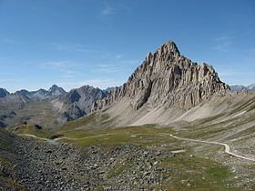
Rocca la Meja is a mountain in the Cottian Alps, in the comune of Canosio, Piedmont, northern Italy. It has an altitude of 2,831 m and it is located in the Maira Valley.
Contents
- Rocca la meja un tonfo per lally
- Map of Rocca la Meja 12020 Canosio Province of Cuneo Italy
- Rocca la meja 2831 mt seconda salita 2011 1 ottobre 2011
- Geography
- SOIUSA classification
- References
Map of Rocca la Meja, 12020 Canosio, Province of Cuneo, Italy
Of pyramidal shape, it is mostly composed of dolostone-like limestone, and stands in a plateau known as Meja-Gardetta.
Rocca la meja 2831 mt seconda salita 2011 1 ottobre 2011
Geography
Administratively the mountain belongs to the Province of Cuneo.
Nearby there is a lake called Lago della Meja.
SOIUSA classification
According to the SOIUSA (International Standardized Mountain Subdivision of the Alps) the mountain can be classified in the following way:
References
Rocca la Meja Wikipedia(Text) CC BY-SA