
Airport type Public / Military Elevation AMSL 1,015 ft / 309 m 10,000 3,048 | Owner U.S. Army ATCA-ASO 15/33 10,000 | |
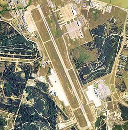 | ||
Location Fort Hood / Killeen, Texas | ||
Robert Gray Army Airfield (IATA: GRK, ICAO: KGRK, FAA LID: GRK) is a military joint-use airport that operates alongside Killeen–Fort Hood Regional Airport. The airport is based inside the south end of the Fort Hood Military Reservation (known as West Fort Hood), six nautical miles (7 mi, 11 km) southwest of the central business district of Killeen, Texas, in unincorporated Bell County.
Contents
As per Federal Aviation Administration records, the airport had 232,299 passenger boardings (enplanements) in calendar year 2008, 231,500 enplanements in 2009, and 243,861 in 2010. It is included in the National Plan of Integrated Airport Systems for 2011–2015, which categorized it as a primary commercial service airport (more than 10,000 enplanements per year).
History
The base was named after a Killeen native who was a pilot of a B-25 bomber on the famous Doolittle Raid on Tokyo in 1942. He was killed later in World War II flying combat missions.
Facilities and aircraft
The airport has one runway designated 15/33 with a PEM (Porous European Mix) surface measuring 10,000 by 200 feet (3,048 x 61 m). For the 12-month period ending April 10, 2010, the airport had 12,208 aircraft operations, an average of 33 per day: 98.5% scheduled commercial and 1.5% general aviation.
The base is also served by Hood Army Airfield (IATA: HLR, ICAO: KHLR, FAA LID: HLR) and two asphalt auxiliary landing strips used for training at North Fort Hood: