
 | ||
Roads in Ukraine (Ukrainian: Авто(мобі́льні) шляхи України, Автошляхи) is a network of roads for public use, for official use, for private use, and streets with city roads. There are three types of roads national, local, and streets. Each type has additional classifications. High-speed highways such as motorways or freeways are rare and only available on selected segments of major routes.
Contents
Overview
The whole network of all automobile roads (highways) consists of some 172,400 km (107,100 mi) out which 164,100 km (102,000 mi) - have hard surface or 95.19%. The existing road network was mostly built in 1960's - 1970's. For comparison in 1940 the highway network of Ukraine consisted of 270,700 kilometers which only 10.8% contained a paved surface.
After the fall of the Soviet Union at the end of 1991 all road service state organizations within Ukraine were reorganized. The highway numbering system was changed as well by the late 1990s. Today more and more cities install their own beltways or ringways to improve their traffic conditions.
Ukravtodor is the state governing body of automobile roads in Ukraine. It is supplemented by a project institute Ukrhiprodor which designs objects of road management. Ukravtodor is supervised by the Ministry of Transportation and Communications. On February 28, 2002 by the Presidential order there was created a state owned open stock company Avtomobilni dorohy Ukrainy (ADU). The company is directly involved in road construction and maintenance. It consists of 32 daughter-companies in each oblast, Crimea, and the cities of national importance. The annual budget of ADU is around 4 billion hryvnias (end of the 2000s).
As of 2016, many of Ukraine's major provincial highways are in very poor condition, with an Ukravtodor official stating that 97% of roads are in need of repair. The road repair budget was set at about 20 billion hryvnias, but corruption causes the budget to be poorly spent and overweight trucks are common place rapidly causing more road damage.
Classifications
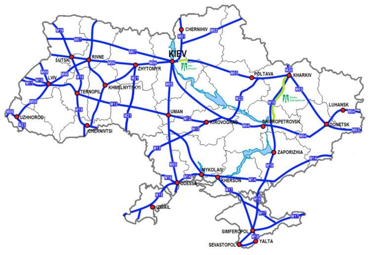
Ukraine has its own network of highway that were inherited from the Ukrainian SSR and were part of the Soviet network of highways. The network consists 99% of roads for public use with 12% assigned as of state importance and 87% - local importance.
The state importance roads have three indexes M, H, P, each stand for the respected letter of Cyrillic. The state importance roads are utilized by the European E-network of highways.
The M-network of roads which stands for International network along with H-network (National) range from 01 to 23 and consist of two digits. These highways are designed for the major transportation corridors across the country and the European highway system.
The P-network (Regional) of roads ranges from 01 to 65 and also is a combination of two digits.
Automagistrals
In Ukraine high-speed divided highways or motorways are called automagistrals which is a generic Russian-type term for high-speed road. Currently automagistrals are not designated into a separate network and are part of national level of expressway network. In the late 2000s there were installed first improved highspeed freeways such as Automagistral Kiev - Boryspil (Ukrainian: Автомагістраль Київ - Бориспіль) which connected the capital with its major airport and another one - Kharkiv - Dnipropetrovsk. Kiev-Boryspil stretches for 18 km (11 mi) and has an ability to allow the traffic volume of 40,000 vehicles on daily basis (24 hrs). It is part of the M03 highway. Important supplemental feature of the automagistral is an electronic informational system that allows to inform the traveling drivers of any updates on the route. That experimental project was installed in 2007 and cost 40 million hryvnia. Kharkiv-Dnipropetrovsk is part of M18 highway.
Road characteristics categories
Aside of classification the roads in Ukraine are categorized by the road's ability to handle a certain degree of traffic. There are five categories with roads of I category split in a and b subcategories. Also all roads of I category are considered automagistrals, however not all of them could be considered as real motorways. Around 2010 there were two major automagistrals: Kiev - Boryspil and Kharkiv - Dnipropetrovsk. They are categorized as the top roads of category Ia.
List of International E-road network in Ukraine
The European routes are part of the International E-road network, routes of which run not only throughout the European continent covering such remote areas as the British Isles, but also parts of the Asian continent regions such as Middle Asia, Caucasus mountains, and Asia Minor. The European routes in Ukraine mostly travel on the Ukrainian International routes network, known as M-network.
In the list below with a green background are identified the main routes. Those are either ones that end with zero (0) or five (5). Note that odd numbers have north-south directions and even numbers - east-west. With the red background are the obsolete routes.
Notes:
Transportation corridors
The European route network creates several important transport corridors known as Pan-European corridors and also including such as Gdańsk-Odessa, Eurasian, Europe-Asia, ChES, and others. There exist a proposition to create a beltway around the Black Sea, traveling through the Crimean peninsula.
Among the Pan-European corridors system, Ukraine houses such corridors as III (Brussels - Dresden - Krakow - Kiev), V (Venice - Budapest - Lviv - Kiev), VII (The Danube river), and IX (Helsinki - Saint-Petersburg - Gomel - Kiev - Chisinau - Bucharest - Thrace).
Important projects
The project was confirmed in 2007 by the Cabinet of Ministers of Ukraine as part of the 2007-2011 program of roads development in Ukraine. The route will start on the border with Hungary at village Kosyny (Zakarpattya Oblast) and will connect to 60 kilometres (37 mi) south of Kiev (between Vasylkiv and Bila Tserkva). It is foretasted to be IA category road with the minimum of 27.5 metres (90 ft) total road width and four lanes (two in each direction). The route includes its major section Vinnytsia - Kiev which will be the first stage project. It was one of the primary construction projects for the 2007-11. The Vinnytsia - Kiev avtomagistral will be 145 kilometres (90 mi) long with the estimated cost of the project is around $1 billion. It also will include 114 artificial constructions such as bridges. The road is planned to be a toll road with an alternative non-toll road running along. The whole Kosyny - Kiev project is estimated at around $5 billion and will include nine tunnels with a total length of 20 kilometres (12 mi) plus 389 other artificial constructions such as bridges, including 29 road interchanges.
The project is estimated at around $5 billion and will include 875 artificial constructions such as bridges and road interchanges (30). It is planned to start the route from near Novomoskovsk with the terminal end at the existing Russian border checkpoint Izvaryne.
Roads of local importance
The local importance roads have three classes as well, but only two indexes T, O. The Raion network of roads does not have a system implemented. The indexes for the local roads are also supplemented by an oblast index where they are located.
Note that the list is arranged in the order of Cyrillic(for some unexplained reasons Chernihiv oblast goes in front of Chernivtsi oblast). For example, the territorial highway 22 in Rivne Oblast would be identified as T-18-22 where 18 is the index for the Rivne Oblast. The T-network (Territorial) as the rest of the roads networks of local importance differs per oblast, but the road numbering itself consists of two digits. The Oblast network (O-network), on the other hand, has the same concept of T-network, but the road numbering contains four digits and the code does not have the hyphen as in T-networks. For example, a highway in Kharkiv Oblast would have code O-21xxxx.
Special routes in Ukraine
There are two main technical terms for special routes: pidyizd (ukr. під'їзд) and obyizd (ukr. об'їзд).
Historical routes
Streets
Types of streets