
- location Mont-Valin - elevation 0 m (0 ft) Basin area 19,000 km² Basin area 19,000 km² Mouth Saint Lawrence River | - location Pointe-aux-Outardes Length 499 km Discharge 400 m³/s Province Québec Country Canada | |
 | ||
- average 400 m/s (14,130 cu ft/s) | ||
Kayak rivi re aux outardes
The Rivière aux Outardes or Outardes River is a river in Quebec, Canada. The river originates in the Otish Mountains, and flows in a southerly direction for its entire course. It passes through Lake Plétipi and Burnt Islands Lake (Îles Brûlées), and widens about midway to form the large Outardes 4 Reservoir. It drains into Outardes Bay of the Saint Lawrence River, about 20 kilometers (12 mi) southwest of Baie-Comeau.
Contents
- Kayak rivi re aux outardes
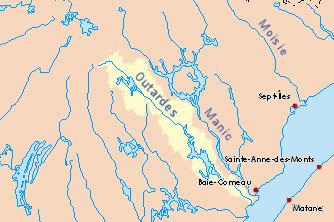
- Map of RiviC3A8re aux Outardes Ragueneau QC Canada
- Migration des outardes ragneneau rivi re aux outardes
- References
Map of Rivi%C3%A8re aux Outardes, Ragueneau, QC, Canada
At its mouth, the Outardes River widens and flows over a sandbar, making it extremely shallow. There are several islands in Outardes Bay of which the most notable are White Island (île Blanche), a rock of white granite 23 meters (75 ft) high, and Mine Island (île de la Mine), a bare red rock reaching 15 meters (49 ft) high.
The river was first called Cane or Caen River by Jean Alfonse in 1544. The name riviere aux Outardes came in use following its appearance on maps by Jacques-Nicolas Bellin in 1744 and 1764. English maps from the end of the 18th century and early 19th century would show "Bustard River", as a translation of the archaic French word bistarde or oustarde. Today outardes is the Canadian French word for Canada geese. The indigenous Innu called the river Pirebistibit, Peritibistokou, Pletipishtuk, or Piletipîstuk Shipu which means "partridge river".
Among its significant tributaries are:
The river has been developed for hydro-electric power generation as part of the Manic-Outardes Project in the 1960s and 1970s. There are three power plants: