
Listing (none) Topo map OS Landranger 154 Prominence 21 m | OS grid TL567480 Elevation 112 m | |
 | ||
Similar Little Trees Hill, Rowley's Hill, Great Wood Hill, Beacon Hill - Norfolk | ||
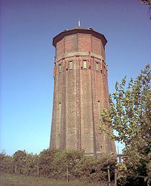
Rivey Hill is a hill overlooking Linton in Cambridgeshire (grid reference TL567480). It is the highest point for several miles around and stands at the height of 112 metres (367 ft). The hill has a steep slope leading down to Linton and a prominence of 21 m. It is crowned by a large watertower which identifies it when seen from distance. The highest point is on private land but a bridleway crosses near the top, ascending from Linton.
Map of Rivey Hill, Cambridge, UK
The ascent of the hill is the start of a pleasant circular walk, detailed in Jarrold's Walks in Cambridgeshire, which goes north from the top to the Roman Road, follows this over Hildersham Hill (95 m) for 2 miles (3.2 km), then descends to Hildersham and returns along the valley of the River Granta to Linton.
References
Rivey Hill Wikipedia(Text) CC BY-SA