
 | ||
Riverside Drive is a scenic north-south thoroughfare in the Manhattan borough of New York City. The boulevard runs on the west side of Manhattan, generally parallel to the Hudson River from 72nd Street to near the George Washington Bridge at 181st Street. North of 96th Street, Riverside Drive is a wide divided boulevard; at other points it divides to provide a serpentine local street with access to the residential buildings. Some of the most coveted addresses in New York are located along its route.
Contents
- Map of Riverside Dr New York NY USA
- Development
- Route
- Riverside Park
- 125th Street viaduct
- Buildings and monuments
- Notable residents
- Film
- Music
- Literature
- Television
- Theater
- References
Map of Riverside Dr, New York, NY, USA
Development
Riverside Drive was designed by landscape architect Frederick Law Olmsted as part of his concept for Riverside Park; the 191 acres (0.77 km2) of land from 72nd to 125th Streets were undeveloped prior to construction of the Hudson River Railroad, built in 1846 to connect New York City to Albany. The first proposal to convert the riverside precipice into a park was contained in a pamphlet written by William R. Martin, a parks commissioner, in 1865. In 1866, a bill introduced into the Legislature by commissioner Andrew Green was approved, the first segment of park was acquired through condemnation in 1872, and construction began.
At the same time, Riverside Drive was being developed as a scenic parkway. Olmsted drew up the plan for the joint Riverside Park and Riverside Drive project. Afterward, several architects started work on the project. Based on Central Park, the new project consisted of "a tree-lined driveway curving around the valleys and rock outcroppings and overlooking the [Hudson] river". From 1875 to 1910, architects and horticulturalists such as Calvert Vaux and Samuel Parsons laid out the stretch of park/road between 72nd and 125th Streets according to the English gardening ideal, creating the appearance that the park was an extension of the Hudson River Valley. Primary construction of the project was completed in about 1910.
In the 1930s, New York Central Railroad's rail track north of 72nd Street was covered in a Robert Moses project called the West Side Improvement. The project, which was bigger than the Hoover Dam project, created the Henry Hudson Parkway and buried the West Side Line in the Freedom Tunnel. It was so skillfully done that many believe the park and road are set on a natural slope. Moses' biographer Robert Caro envisaged Moses surveying the area before his project, finding:
a wasteland six miles (10 km) long, stretching from where he stood all the way north to 181st street...The 'park' was nothing but a vast low-lying mass of dirt and mud. Unpainted, rusting, jagged wire fences along the tracks barred the city from its waterfront...The engines that pulled trains along the tracks burned coal or oil; from their smokestacks a dense black smog rose toward the apartment houses, coating windowsills with grit...[a stench] seemed to hang over Riverside Drive endlessly after each passage of a train carrying south to the slaughterhouses in downtown Manhattan carload after carload of cattle and pigs.
In the 1980s Donald Trump, then owner of the 57 acres (230,000 m2) of land just south of Riverside Park that had been the Penn Central freight rail yard, proposed a very large real estate development project. However, hampered by his weakened financial condition and opposed by six civic groups (Municipal Art Society, Natural Resources Defense Council, The Parks Council, Regional Plan Association, Riverside Park Fund, and Westpride), Trump agreed in 1990 to their scaled-down plan, still the second biggest private real estate venture under construction in New York City. The agreed-upon plan would expand Riverside Park by 23 acres (93,000 m2). Riverside Drive, also included in the design, would be extended to the south as Riverside Boulevard.
Route
Today, Riverside Drive passes through the Manhattan neighborhoods of the Upper West Side, Morningside Heights, over Manhattanville in West Harlem by way of the Riverside Drive Viaduct and through Washington Heights. Riverside Drive starts at 72nd Street as a narrow parkway and a continuation of Riverside Boulevard; the latter stretches through Riverside Park South (a.k.a. Trump Place, for its developer) to 62nd Street.
Only a few stretches of Riverside Drive were built along an older road; due to the hilly terrain, Riverside Drive crosses a natural cleft in the bedrock at 87th Street on an iron viaduct and passes over 96th Street, Tiemann Place and 135th Street, and 158th Street on further viaducts. At Tiemann Place and 135th Street, and at 158th Street, an old alignment is present, also named Riverside Drive, while the viaduct portion or main route is officially named and signed "Riverside Drive West". The viaduct between Tiemann Place and 135th Street is called the "Riverside Drive Viaduct", as it is the most notable of the Riverside Drive viaducts.
At its north end, Riverside Drive merges with the northbound lanes of the Henry Hudson Parkway. In 2005, the retaining wall of Castle Village collapsed onto both Riverside Drive and the northbound lanes of the Henry Hudson Parkway. The wall was repaired and the roadway reopened in March 2008.
Riverside Drive terminated at Grant's Tomb in a cul-de-sac, prior to the construction of the Manhattan Valley viaduct, spanning 125th Street, completed in 1900. North of 158th Street the right of way which currently carries the name Riverside Drive was known as Boulevard Lafayette, which led to Plaza Lafayette in Hudson Heights. The section exiting the parkway at the Dyckman Street exit and ending at Broadway is still known as Riverside Drive.
The M5 New York City Bus route serves Riverside Drive from 72nd to 135th Streets. The Bx6 terminates at Riverside Drive and 158th Street.
Riverside Park
Riverside Park, part of the Manhattan Waterfront Greenway, is a scenic waterfront public park on a narrow 4 miles (6.4 km) strip of land between the Hudson River and Riverside Drive. It is approximately 266.971 acres (108 ha). The new Riverside Park South, stretching between 72nd and 59th streets, is the central element of the Riverside South development. Portions of the former rail yard, such as the New York Central Railroad 69th Street Transfer Bridge, are incorporated into the new park.
125th Street viaduct
The elevated steel highway of the 125th Street viaduct, called the Riverside Drive Viaduct, between Tiemann Place and 135th Street and rising over Twelfth Avenue, is shouldered by masonry approaches. The viaduct proper was made of open hearth medium steel, comprising twenty-six spans, or bays, whose hypnotic repetition is much appreciated from underneath at street level. The south and north approaches are of rock-faced Mohawk Valley limestone with Maine granite trimmings, the face work being of coursed ashlar. The girders over Manhattan Street (now 125th Street) were the largest ever built at the time. The broad plaza effect of the south approach was designed to impart deliberate grandeur to the natural terminus of much of Riverside Drive’s traffic as well as to give full advantage to the vista overlooking the Hudson River and New Jersey Palisades to the west.
F. Stuart Williamson was the chief engineer for the viaduct, which constituted a feat of engineering technology. Despite the viaduct's important utilitarian role as a highway, the structure was also a strong symbol of civic pride, inspired by America’s late 19th-century City Beautiful movement. The viaduct’s original roadway, wide pedestrian walks and overall design were sumptuously ornamented, creating a prime example of public works that married form and function. An issue of the Scientific American magazine in 1900 remarked that the Riverside Drive Viaduct's completion afforded New Yorkers “a continuous drive of ten miles along the picturesque banks of the Hudson and Harlem Rivers.” The viaduct underwent a two-year-long reconstruction in 1961 and another in 1987.
Buildings and monuments
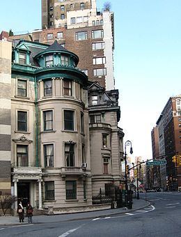
The eastern side of Riverside Drive, once a series of luxuriously finished rowhouses interspersed with free-standing nineteenth century mansions set in large lawns, today is lined with luxury apartment buildings and some remaining town houses from 72nd to 118th Streets.
The brick-faced Schwab House occupies the site of "Riverside", built for steel magnate Charles M. Schwab, formerly the grandest and most ambitious house ever built on the island of Manhattan. Among the more eye-catching apartment houses are the curved facades of The Colosseum and The Paterno and the Cliff-Dwellers Apartments at 96th Street, with mountain lions and buffalo skulls on its friezes. The Henry Codman Potter house at 89th Street is one of the few remaining mansions on Riverside Drive; it houses Yeshiva Chofetz Chaim. 310 Riverside Drive, a landmarked 24-story Art Deco skyscraper, is near Columbia University and the 370 Riverside Drive building, which was erected in 1922–23 for approximately $800,000 by Simon Schwartz and Arthur Gross. Also, the Nicholas Roerich Museum is on 107th Street and Riverside Drive. The Riverside Church is located at 120th Street and Riverside Drive.
Among the monuments, sights, and institutions along its route are the Eleanor Roosevelt statue by Penelope Jencks, the Soldiers and Sailors Monument, Anna Hyatt Huntington's Joan of Arc, the Fireman's Memorial at 100th Street (a focus of spontaneous dedications of flowers and teddy bears after the September 11 attacks) Grant's Tomb, The Interchurch Center, Riverside Church, Sakura Park, Riverbank State Park, Trinity Church Cemetery, Columbia-Presbyterian Medical Center, and Fort Washington Park. Across from the Henry Codman Potter house is the Soldiers and Sailors Monument (1902). At 99th Street is a memorial to Beaux-Arts architect John Merven Carrère by his partner Thomas Hastings. The Firefighters' Memorial at 100th Street was sculpted by Attilio Piccirilli. It was installed in 1913 and restored in the late 20th century.