
 | ||
A river anticline is a geologic structure that is formed by the focused uplift of rock caused by high erosion rates from large rivers relative to the surrounding areas. An anticline is a fold that is concave down, whose limbs are dipping away from its axis, and whose oldest units are in the middle of the fold. These features form in a number of structural settings. In the case of river anticlines, they form due to high erosion rates, usually in orogenic settings. In a mountain building setting, like that of the Himalaya or the Andes, erosion rates are high and the river anticline's fold axis will trend parallel to a major river. When river anticlines form, they have a zone of uplift between 50-80 kilometers wide along the rivers that form them.
Contents
Cause and Effect
The type of geologic feature that will form is caused by stream power and flexural rigidity of the crust. When stream power increases and flexuaral rigidity decreases, this causes the structure to progress from a transverse anticline to a river anticline, and in extreme cases to a tectonic aneurysm. Transverse anticlines trend in the direction of and form around small rivers with relatively high crustal strength. River anticlines form around large highly erosive rivers where crustal strength is relatively low. Tectonic aneurysms will form when erosion is very high and the crust is very weak, to form a structural welt.
The way that river anticlines form via deep river incisions and the associated crustal rebound, cause rocks deep in the crust to be preferentially exhumed along large rivers like the Arun, Indus, Sutlej, and Yarlung Zangbo River. Isolated exhumation causes high pressure and ultra high pressure metamorphic sample to be brought to the surface at sustained rates of up to 5mm per year. Analysis and radiometric dating of these high pressure and ultra high pressure metamorphic rocks can help reconstruct the tectonic evolution of the orogenic belt that formed them.
Evidence
In the Himalaya, the Indian continental plate is crashing into the Eurasian continental plate with nearly north-south motion. Therefore, the compression of the rocks in the Himalaya is in the north-south direction. So, folding should occur trending east-west, as is observed. However, it has also been noted that folding occurs in the north-south direction. It was noted that these folds follow the traces of the major rivers, such as the Arun and the Indus. Originally these folds were explained by assuming that the rivers did not form these anticlines, instead the river's course was by coincidence on top of these geologic features, forming by differential erosion. The idea of isostatic rebound was suggested as the best fit mechanism for these north-south trending folds and is now widely accepted.
Formation processes
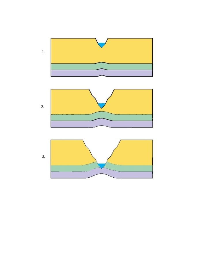
The formation of a river anticline by isostatic rebound is illustrated in the figure to the right in idealized steps. The principle of Isostasy says that if the lithosphere is free to move vertically, then it will float at an appropriate depth in the asthenosphere based on the thickness and density of the lithosphere. River anticlines form when huge amounts of material are removed by river erosion in an area with low crustal rigidity. The crust rebounds up specifically along the river, while the rest of the area remains relatively constant. This will bend the crust forming an anticline, which can take up to ten thousand years. As a river flows through the area, it erodes away large amounts of the overlying rock, which causes a decrease in the lithosphere's mass, leading to an isostatic response. With no overlying rock, the underlying material rebounds up, like removing a weight from a raft. As the river progresses the erosion continues and therefore the rebounding continues, which will form a low wide antiformal structure. For this rebound to occur the erosion from the river must exceed the average erosion rate for the area and exceed the uplift of the orogen. The average erosion rates for the Himalaya are about 1 mm per year, while the erosion rate for the Arun River of the eastern Himalaya is up to 8 mm per year, so it makes sense that we would see river anticlines along the Arun River.
Tectonic aneurysms
A tectonic aneurysm is an isolated zone of extreme uplift and exhumation rates. This forms when uplift from local tectonics are combined with very weak crust and uplift from a river anticline. When a major river flows over an area of tectonic uplift, the erosion from the river will erode the uplifted material. This will cause extremely rapid exhumation along the major rivers, of up to 10 mm per year. Within the Himalaya there are two tectonics aneurysms each on one of the two syntaxis of the orogenic belt, Nanga Parbat in the west and Namche Barwa in the east. These tectonic aneurysms form in similar ways to river anticlines, but with extreme erosion rates and very weak and ductile crust. The syntaxis mark the end of the Himalayan orogen on either side and define the location of two large rivers, the Indus and the Yalu Tsangpo. The syntaxis on either side of the Himalaya are dominated by a strike slip fault zone, instead of a compressional thrust faulting, as in the rest of the orogen. In the west the Indus river flows through the Nanga Parbat and in the east the Yarlung Tsangpo River flows through the Namche Barwa. The very high erosion rates of these two rivers is coupled with weak, hot, thin, dry, crust to form areas of extreme uplift and exhumation.