
Country United Kingdom | Basin area 258 km² | |
 | ||
- right Wesley Brook (2), Mad Brook | ||
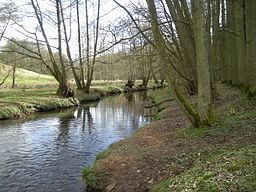
The River Worfe is a river in Shropshire, England. The name Worfe is said to derive from the Old English meaning to wander (or meander) which the river is notable for in its middle section. Mapping indicates that the river begins at Cosford Bridge where the Cosford Brook and Albrighton Brook meet (Cosford Brook, a local name, is itself the confluence of the Ruckley Brook and Neachley Brook).
Contents
Map of River Worfe, United Kingdom
Course
It rises at Crackleybank on Watling Street, just north of Shifnal. It then forms the boundary of that parish with Tong, Donington, and Albrighton. It then passes through Ryton (where it is joined by Wesley Brook), and Beckbury. There it is joined by Mad Brook, which takes its name from Madeley through where it first flows. Soon after, it forms the boundary between Stockton and Badger, before flowing through Worfield to join the River Severn. The river flows downhill to the Severn at an average rate of 10 feet per mile so that between the source and its mouth there is a drop of 200 feet (61 m).
The river has two outlets to the River Severn, of which the southern emerging at Fort Pendlestone was formerly the mill leat serving Pendlestone Mill, the ancient corn mill of the town of Bridgnorth and long belonging to Bridgnorth Corporation.
Due to the low flow problems affecting the river in its upper reaches, a pipeline was constructed in 1998 between a borehole at Sheriffhales and Ruckley Brook north of the A5.
The Severn Rivers Trust carried out remedial works to the river and its banks in March 2015. Six community groups and 27 volunteers installed 5.0 miles (8 km) of fencing, installed numerous eel and fish passes and created 4.6 miles (7.4 km) of new channelling in an effort to improve the river's ecological status.