
- location Newbridge Length 65 km | - average 3.27 m/s (115 cu ft/s) Discharge 3.27 m³/s Country United Kingdom | |
 | ||
- max 21.6 m/s (763 cu ft/s) 6 December 1960 - min 0.11 m/s (4 cu ft/s) 26 August 1976 | ||
Cotswolds country walk the mousetrap inn to the slaughters and the river windrush
The River Windrush which winds through the rushes for much of its course, hence its name, is a stream and river in the English Cotswolds in the upper Thames catchment.
Contents
- Cotswolds country walk the mousetrap inn to the slaughters and the river windrush
- Map of River Windrush United Kingdom
- Swans at burford bridge on river windrush oxfordshire england uk
- References
Map of River Windrush, United Kingdom
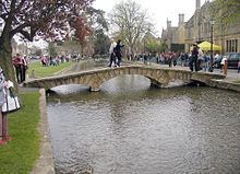
The Windrush starts in the Cotswold Hills in Gloucestershire northeast of Taddington, which is north of Guiting Power, Temple Guiting, Ford and Cutsdean. It flows for about 35 miles (56 km): through Bourton-on-the-Water, by the village of Windrush, Gloucestershire, into Oxfordshire and through Burford, Witney, Ducklington and Standlake. It meets the Thames at Newbridge upstream of Northmoor Lock.
The river is host to fish, including trout, grayling, perch, chub, roach and dace. It held good populations of native crayfish until at least the 1980s. River waters were used in cloth and woollen blanket making in Witney from mid 17th century. In 2007, the Windrush was one of many rivers in the area to flood. Towns and villages along the length of the river were affected, perhaps most acutely in Witney, which was cut in half by the closure of the only bridge across the river.