
- location Lods Bridge Basin area 52 km² Basin area 52 km² | - elevation 140 m (459 ft) - average 0.58 m/s (20 cu ft/s) Discharge 0.58 m³/s Source Marley Heights | |
 | ||
- max 41.5 m/s (1,466 cu ft/s) 27 December 1979 - min 0.01 m/s (0 cu ft/s) 7 September 1991 | ||
The River Lod is a short river draining about 52 km2 (20 sq mi) of north west Sussex. The source is on Marley Heights near Haslemere, about 140 metres above sea level. From here it flows west past Linchmere, then south to Furnace Pond, where iron cannon were cast during the English Civil War. It then turns south east, flowing south of Fernhurst to Lickfold and Lurgashall where it formerly powered Lurgashall Mill, now moved to the Weald and Downland Open Air Museum. From Mill Farm it heads south between high banks, which it only overflows after the heaviest of rainfalls, passing between the hills of Lodsworth and River to Halfway Bridge on the A272 road then joining the River Rother at Lods Bridge.
Contents
North Park FurnaceEdit
Iron was produced by a blast furnace on the boundary of Fernhurst and Linchmere parishes. Water to power the bellows was provided by an artificial lake covering about 2.5 hectares created by a dam on the river. There was also a higher pond 400 metres north-west of the furnace to provide a reserve supply as continuity of production is vital for a blast furnace.
Lurgashall MillEdit
Another artificial lake between Lurgashall and Lodsworth supplied water to power Lurgashall Mill, producing flour. The mill is now operated at the Weald and Downland Open Air Museum.
Lords Wood BarnsEdit
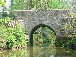
Formerly named Lodge Farm the old barns on the east bank of the river by Lords Wood were converted into offices for Sofa Workshop Company in 1996, saving the older barn from imminent collapse. The east pier of the bridge had sunk several centimetres before the bridge was underpinned and repaired at that time to carry the newly built road through the wood from the Lodsworth to Lickfold road. The Serpent Trail long distance path crosses the river here.