
Time zone AST (UTC-4) Telephone Exchange 351 Population 2,399 (2006) | Postal code B0K 1N0 Area 430 km² Local time Sunday 6:50 PM Area code 902 | |
 | ||
Communities Bigney, Black River, Brook Road, Cape John, Caribou River, College Grant, Diamond, Dufferin, East Branch River John, Elmfield, Fitzpatrick, Hedgeville, Hodson, Loganville, Louisville, MacKays Corner, Marshville, Meadowville, Melville, Mountain Road, Plainfield, Poplar Hill, River John, Rogers, Seafoam, Sundridge, Toney Mills, Toney River, Welsford, West Branch River John, Westerly Weather 0°C, Wind E at 11 km/h, 55% Humidity | ||
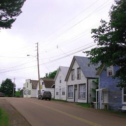
River John is an unincorporated community in Pictou County, Nova Scotia, Canada.
Map of River John, NS, Canada
It is located near the mouth of the River John on the Northumberland Strait, halfway between Pictou and Tatamagouche near the boundary with Colchester County. It is on Nova Scotia Trunk 6 and the designated tourist route, the Sunrise Trail.
River John was colonized by Europeans during the 18th century and its port and the proximity of plentiful timber led to the development of a small shipbuilding industry.
Today the local economy is based on the seasonal industries of fishing, agriculture, and tourism. The area is a popular summer cottage location for residents of Halifax and other urban areas in the province. The village supports a few local shops, a library, several churches, a post office and a volunteer fire department. The K-9 school was closed in 2015.
The Nova Scotia folklorist W. Roy MacKenzie (1883–1957) lived in River John.