
- elevation 0 ft (0 m) | Length 8 km Country United Kingdom | |
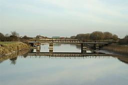 | ||
River huntspill m5 to gold corner near bridgwater somerset
The River Huntspill (or Huntspill River) is an artificial river, in the Somerset Levels, in the Sedgemoor district of Somerset, England. It was built in 1940 to supply process water to ROF Bridgwater, and has resulted in reduced flooding of the lower Brue Valley. Huntspill Sluice at the river's western end, also known as West Huntspill Sluice, separates it from the River Parrett.
Contents
- River huntspill m5 to gold corner near bridgwater somerset
- Map of Huntspill River United Kingdom
- HistoryEdit
- Flora and faunaEdit
- References
Map of Huntspill River, United Kingdom
A large section of the river and its surrounding lands has been designated as a National Nature Reserve which is managed by the Environment Agency.
HistoryEdit
The concept for the Huntspill River was first suggested by J. Aubrey Clark in 1853, as a way of improving the drainage of the lower River Brue.
At the outbreak of World War II a new explosives factory, ROF Bridgwater, was proposed. This would need 4.5 million imperial gallons (20 Ml; 5.4M US gal) of process water per day. Louis Kelting, the Chief Engineer of the Somerset Catchment Board revived Clark's plans, and combined the water supply solution with a drainage scheme. In addition to supplying water to the factory an area of 45,000 acres (18,000 ha) was drained of which 4,000 acres (1,600 ha) regularly flooded.
A 5-mile (8.0 km) straight channel was excavated using a dragline excavator during the early years of World War II. It was constructed as a priority war work, because of its importance to the munitions factory. The plans had been drawn up in late 1939, and by January 1940 the first excavations were being made.
It ran from Gold Corner, where it was connected to the South Drain, to a new outfall on the estuary of the River Parrett, and had retention sluices at both ends, so that it acted as a long reservoir. It was intended that in the summer, when water supply was lower, it would serve as a reservoir with water pumped from the moors; in winter as a drainage channel, via gravity drainage.
The plans were for a 25-foot (7.6 m) channel, with the excavated earth used to create flood banks at its edges. At this depth, water could flow into it from the moors by gravity, but problems were experienced with the design. Because the underlying soil was peat, the weight of the flood bank caused it to rotate and push upwards in the bottom of the channel. Experiments were carried out to find the optimum size for a stable channel, and the result was one that was only 16 feet (4.9 m) deep. The flood banks could not exceed 15 feet (4.6 m) in height, and had to be set back from the edge of the channel by at least 30 feet (9.1 m). Because of the lack of depth, water from the South Drain had to be pumped into the river. The existing pumping station at Gold Corner could not cope with all the water from the drain, as well as flood water from the moors, so had to be enlarged.
Once the entire flow of the South Drain was entering the river, the section northwards from Gold Corner to the River Brue became redundant. Rather than allow it to silt up, it was enlarged, and Cripps sluice constructed where it met the Brue. This enabled water from the Brue, which had nowhere to go because its outlet was blocked by high tides, to be diverted southwards to the Huntspill river, with the result that flooding in the Brue valley was significantly reduced. The pumping station, with four Sultzer horizontal pumps which are powered by two-cylinder oil engines made by Crossley, has since been modernised including the conversion of one of the pumps to use electricity and replacing the fuel tanks.
Flora and faunaEdit
A 148 hectares (370 acres) stretch of the river, from Gold Corner to Huntspill Sluice (excluding the Cripps River), is a National Nature Reserve. The NNR is managed by the Environment Agency, rather than by Natural England, responsible for most of the other reserves in England. This arrangement is authorised by section 35 of the Wildlife and Countryside Act 1981, and funding for the maintenance and upkeep of the river as a reserve is still provided by Natural England. The river and its catchment area include several Sites of Special Scientific Interest: Street Heath, Shapwick Heath, Westhay Heath and Catcott, Edington and Chilton Moors.
The river discharges into the River Parrett just south of Highbridge. The Parrett flows into Bridgwater Bay, which is also an important National Nature Reserve, on the edge of the Bristol Channel.