
- average 0.86 m/s (30 cu ft/s) Discharge 0.86 m³/s Country United Kingdom | - elevation 200 m (656 ft) - elevation 79 m (259 ft) Length 25 km | |
 | ||
- max 4.70 m/s (166 cu ft/s) 31 January 1971 | ||
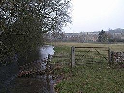
The River Churn is the first tributary river of the River Thames. It rises in the Cotswolds at Seven Springs near Cheltenham, Gloucestershire, England and flows south across the Cotswold dip slope, passing through Cirencester and joining the Thames in the parish of Cricklade in Wiltshire. Its length from source to confluence with the Thames is considerably greater than the Thames from Thames Head. Its flow is also more consistent than the winterbourne Thames, but the Churn is regarded as a tributary historically and therefore by most geography guides. The length of the River Churn is approximately 25 kilometres. The River Churn is classed as a main river so therefore is under the jurisdiction of the Environment Agency as opposed to the local authority.
Map of River Churn, United Kingdom
The name Churn is ancient, certainly pre-Roman and probably has its origins in the Celtic language, spoken by the Dobunni tribe, who controlled the area before the Roman conquest in the 1st Century. The original name may have sounded similar to Korinn. It has been suggested that the origin of the word is associated with the ancient British Cornovii tribe.
Cognate names and name elements from the area are Cerney, Ciren and Corin as found in the settlement names of North Cerney, Cirencester, South Cerney, and Cerney Wick in the south of South Cerney. Cirencester's original recorded name Corinium Dobunnorum also shares this root. All these places adjoin the River Churn. The Coln and the Thames feed the waters of a western bisection of the Cotswold Water Park, converted redundant gravel beds between Cirencester and Cricklade.
Much of the catchment basin of the River Churn is known to have been an important area of Roman settlement in the second to fourth centuries AD.
As of the year 2006 the national government is engaged in a planning study to analyse methods of mitigating future flooding associated with the River Churn. However, at times the River Churn is known to stop flowing completely; in September 2011 the river bed was completely dry at Latton.