
Country United Kingdom | ||
 | ||
- location Stoneleigh Park, Derker | ||
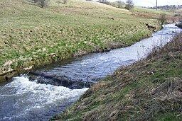
The Beal is a small river in Greater Manchester, England, and is a tributary of the River Roch. It rises in the Beal Valley in green space between Sholver and Royton, before continuing northwards through Shaw and Crompton, Newhey, Milnrow and Belfield.
Contents
Map of River Beal, United Kingdom
Course
From its source at Beal Valley, it flows north through Shaw and Crompton in the Metropolitan Borough of Oldham, where Old Brook and Pencil Brook are tributaries. It continues north through Newhey and Milnrow in the Metropolitan Borough of Rochdale, before joining the River Roch at Belfield.
In part, the river forms a boundary between Oldham on one side and Royton and Shaw and Crompton on the other.
History
The name Beal is believed to come from the Brythonic word "Bel" meaning "raging torrent".
1212 : The Beal valley was recorded as part of the thegnage estate of Kaskenmoor, held on behalf of King John by Roger de Montbegon and William de Nevill.
1892 : Ellenroad Cotton Mill was built on the bank of the Beal, and made fine cotton yarn by mule spinning.
During operation of a bleaching and dying works, discharge to the river of used dyes and waste would cause it to change colour from one day to another.
c. 1997 : Littlewoods PLC changed the course of the river slightly to allow development of their Shaw National Distribution Warehouse Centre.
2005 : Raw sewage was discharged to the river, killing thousands of fish and raising health fears among local residents.