
Main source Guayama, Puerto Rico Mouth Atlantic Ocean Sources Guayama, Cayey | Length 97 km Country Puerto Rico | |
 | ||
River mouth Atlantic Ocean, at Dorado Bridges Jesús Izcoa Moure Bridge, Plata Bridge | ||
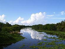
The Rio de la Plata is the longest river in the island of Puerto Rico. It is located in the north coast of the island. It flows from south to north, and drains into the Atlantic Ocean about 11 miles (18 km) west of San Juan. The mouth of the river is a resort area with white sandy beaches.
Contents
Map of R%C3%ADo de la Plata, Dorado, Puerto Rico
La Plata has a length of approximately 60.5 miles (97 kilometers) with its origin in the municipality of Guayama, Puerto Rico, at an altitude of approximately 2,625 feet (800 meters) above sea level. It crosses the municipalities of Guayama, Cayey, Comerío, Naranjito, Toa Alta, Toa Baja, and Dorado forming two lakes on its path: Carite Lake and La Plata Lake.
There are many crossings of the river. The Arenas Bridge, in Cayey, is one of the most notable. It is a steel bridge built in 1894 and is still in use. It was the longest bridge built in Puerto Rico by the Spanish.
The United States Army Corps of Engineers is undertaking a major flood control project in the river basin.
History
The Taíno Indians referred to the river as "thoa" which means mother, which itself gave the name to the towns of Toa Alta and Toa Baja located in the mouth of the river to the Atlantic Ocean.