
Construction masonry tower Intensity 600.000 candela Height 29 m Automated 1998 Year first constructed 1825 | Light source solar power Focal height 46 m Range 44,448 m NGA number 4232 | |
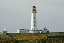 | ||
Tower shape cylindrical tower with balcony and lantern Markings / pattern white tower, black lantern, ochre trim | ||
The Rinns of Islay (Scottish Gaelic: Na Roinn Ìleach; alternative English spelling Rhinns of Islay) is an area on the west of the island of Islay in the Inner Hebrides of Scotland.
Map of Rhinns of Islay, Isle of Islay, UK
It is a peninsula that is attached to the main body of the island at its northern end. The main population centres are Port Charlotte and Portnahaven, based on the A847 that runs along its eastern coast.
It is designated a Special Protection Area due to its importance for a number of breeding and wintering birds, particularly Greenland white-fronted goose and chough. The significance of the area owes much to its wide variety of habitats including bog, moorland, dune grassland, maritime grassland, marsh and extensively-farmed agricultural land.
The Rinns of Islay lighthouse is located on the island of Orsay.
The Rhinns complex, a deformed igneous complex that is considered to form the basement to the Colonsay Group of metasedimentary rocks takes its name from the Rhinns of Islay.