
Max. width 0.7 km (0.4 mi) Surface elevation 39 m Catchment area 178.1 km² Province Connacht | Primary outflows Rinn River Max. length 4 km (2.5 mi) Surface area 1.65 km (0.64 sq mi) Area 165 ha Catchment area 178.1 km² | |
 | ||
Rinn Lough (Irish: Claonloch, also Irish: Loch na Reanna), also known as Lough Rynn, is a freshwater lake in the northwest of Ireland. It is located in south County Leitrim.
Contents
Map of Rinn Lough, Co. Leitrim, Ireland
Geography
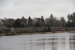
Rinn Lough measures about 4 km (2.5 mi) long and 1 km (0.6 mi) wide. It is located about 4 km (2 mi) south of Mohill. Lough Rynn Castle, a medieval castle now a hotel, occupies an estate on the lake's northeastern shore.
Hydrology
Two smaller neighbouring lakes drain into Rinn Lough: Clooncoc Lough and Lough Errew. Rinn Lough drains south into the Rinn River flowing into Lough Forbes. Part of the river forms the Rinn River Natural Heritage Area.
Ecology
The water quality was reported to be satisfactory c. 2001 – c. 2006 maintaining a mesotrophic rating. but given a "bad ecological status" c. 2007 – c. 2009 due to pollution. Zebra mussel infestation is present. The ecology of Rinn Lough, and Irish waterways, remains threatened by curly waterweed, zebra mussel, and freshwater clam invasive species.