Suvarna Garge (Editor)

Riddarfjärden

Updated on
Edit
Like
Comment
Share on FacebookTweet on TwitterShare on LinkedInShare on Reddit
Riddarfjärden photoswikimapiaorgp0003937417bigjpg

Bridges
  
Västerbron, Centralbron, Riddarbron

Similar
  
Gamla stan, Riddarholmen, Stockholm City Hall, Västerbron, Långholmen

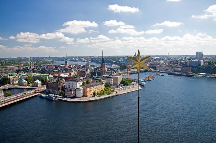
Riddarfjärden ([²rɪdːarˌfjæːɖɛn], "The Knight Firth") is the easternmost bay of Lake Mälaren in central Stockholm. Stockholm was founded in 1252 on an island in the stream where Lake Mälaren (from the west) drains into the Baltic Sea (to the east); today the island is called Stadsholmen and constitutes Stockholm's Old Town.

Contents

Map of Riddarfj%C3%A4rden, Stockholm, Sweden

The panorama picture featured in this article was taken from the heights of Södermalm, west of Stadsholmen, looking down on Riddarfjärden. Left to right are viewable:

  • Västerbron bridge
  • Kungsholmen Island
  • Stockholm City Hall, a red brick building with a bell tower, where the Nobel Prize dinner is served
  • The tower of Klara Kyrka on Norrmalm, with its green copper roof
  • five white sky scrapers between Sergels torg and Hötorget
  • construction cranes
  • iron tower of Riddarholmen Church on Riddarholmen Island
  • yellow tower of Storkyrkan on Stadsholmen, in front of the flat roof of the Stockholm Palace
  • narrow tower of Tyska Kyrkan on Stadsholmen
  • distant radio and TV tower Kaknästornet
  • SeasonsEdit

    Riddarfjärden during the year

    References

    Riddarfjärden Wikipedia