
Length 8 km | River mouth Atlantic Ocean | |
 | ||
Main source Cabo da Ribeira nearPico da CruzSanto Antão | ||
Ribeira do paul 2012
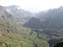
Ribeira do Paul is a stream that flows in the northeastern part of the island of Santo Antão in Cape Verde. The stream flows from southwest to northeast and is nearly 8 km in height. The entire valley belongs to Cova-Ribeira da Torre-Paul Natural Park.
Contents
It is the area that the Capeverdean drink grogue is the most popular on the Island of Sãnto Antao.
Paul flyfishing ribeira do paul wmv
Geography
The stream begins northwest of the mountain top and the caldera (Cabo da Ribeira) of Pico da Cruz (1583 m). The river flows through a narrow steep gorge, some of which has been terraced and is irrigated to support agricultural production including sugar canes, coffees, banana and mandioka. The river flows into the Atlantic Ocean at the town of Pombas. Other settlements along the river include Eito de Baixo and Eito. Other features along the river including Chã de Canela, Lombo Comprido, Dragoeiro, Chã de Erva, Lombo de Joana, Lombinho, Chã de João Vaz, Chã de Padre, Ladeira and Chãzinha.
Flora
Endangered flora includes Tornabenea insularis.