
OS grid reference SJ073750 Sovereign state United Kingdom Postcode district LL17 Local time Wednesday 1:44 PM Dialling code 01745 Welsh assembly Vale of Clwyd | Country Wales Post town ST. ASAPH | |
 | ||
Weather 13°C, Wind S at 13 km/h, 81% Humidity | ||
Driving down rhuallt hill st asaph a55 expressway north wales uk
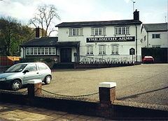
Rhuallt is a village in Denbighshire, Wales. The village is situated approximately 5 mi (8.0 km) south of Prestatyn and 2 mi (3.2 km) east of St Asaph on the B5429 road, adjacent to the A55, and has a caravan site. There are two public houses, The Smithy Arms and the White House, and the post office was described in the BBC Domesday Project of 1986.
Contents
- Driving down rhuallt hill st asaph a55 expressway north wales uk
- Map of Rhuallt Saint Asaph UK
- Cycle route from rhuallt to st asaph via pont dafydd
- References
Map of Rhuallt, Saint Asaph, UK
Cycle route from rhuallt to st asaph via pont dafydd
References
Rhuallt Wikipedia(Text) CC BY-SA