
Demonym(s) Rhenenaar Postcode 3910–3922 Area 43.74 km² Local time Wednesday 8:07 AM | Elevation 43 m (141 ft) Time zone CET (UTC+1) Area code 0317, 0318 | |
 | ||
Weather 11°C, Wind SW at 14 km/h, 86% Humidity | ||
Rhenen ( pronunciation ) is a municipality and a town in the central Netherlands. The municipality also includes the villages of Achterberg, Remmerden, Elst and Laareind. The town lies at a geographically interesting location, namely on the southernmost part of the chain of hills known as the Utrecht Hill Ridge (Utrechtse Heuvelrug), where this meets the river Rhine. Because of this Rhenen has a unique character with quite some elevation through town.
Contents
Map of Rhenen, Netherlands
Directly to the east of the built-up area lies the Grebbeberg, a hill with a top elevation of about 50 metres (160 ft).
Before 1900
Rhenen received city rights probably between 1256 and 1258. In 1346, the bishop of Utrecht ordered the construction of a defensive wall around the city, which was important because it lay near the border with Guelders. Although for some time the town collected toll from ships on the Rhine, it has never had a harbour. The three city gates were demolished in 1840. Small fragments of the wall remain.
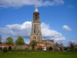
The town is also famous for the Cunera Church, parts of which date back to the 15th century. Containing the relics of Saint Cunera, it attracted many pilgrims. Legend has it that Cunera was buried on a nearby hill now called the Cuneraheuvel. The church's tower was built between 1492 and 1531.
In 1621, a palace was constructed at Rhenen for the ousted Frederick V. It was demolished in 1812.
World War II
Part of the center of Rhenen, which was located near the defensive Grebbelinie (Grebbe line), was destroyed during the German attack on the Netherlands in May 1940. Part of the reconstruction took place during the war. In 1945, the town was damaged again during the liberation of the country from German occupation.
Many or all of the Dutch soldiers who were killed by the Germans near Rhenen lie buried at the Erebegraafplaats (Cemetery of Honor), located along the Grebbeweg (N 225) near the top of the Grebbeberg. Across the road is an important war monument with a poem by J.C. Bloem.
In 2008 Rhenen celebrated its 750th anniversary.