
Elevation 779 m (2,556 ft) Postal code 09496 | Time zone CET/CEST (UTC+1/+2) Dialling code 037364 | |
 | ||
Reitzenhain is a village in the Ore Mountains which is now a subdivision of Marienberg in the district Erzgebirgskreis.
Contents
Map of Reitzenhain, 09496 Marienberg, Germany
Geography
Reitzenhain is located on the crest of the Ore Mountains, next to the border between Germany and the Czech republic at an altitude of ca. 778 m (station building) on the stream Schwarze Pockau. The abandoned village Pohraniční (Böhmisch Reizenhain) is situated to its south-east, on the Czech side of the border and on the right bank of the stream.
Etymology
The name of the village is supposedly derived from a wayside inn (locally called a Han) on the nearby mountain pass, which happened to be the thirteenth inn ('Dreizehnter Han') on the road from Leipzig to Prague, counted from either end. This is also reflected by the number "13" (German: 'Dreizehn') in the village's coat of arms.
History
Reitzenhain was first mentioned in a document of 1401 as Reiczenstein, being a village on the border to Bohemia. In 1551 it belonged to Großrückerswalde parish, in 1607 it was transferred to Kühnhaide parish. Reitzenhain children also attended school in Kühnhaide. Due to the strategically important location on the Reitzenhain pass, the village was frequently occupied by military forces, in particular in the Thirty Years' War and in the Seven Years' War. Until 1856 Reitzenhain belonged administratively to Amt Wolkenstein.
The road between Marienberg and Reitzenhain was improved to rural highway standards in the first half of the 19th century. The railway from Chemnitz to Komotau via Marienberg was opened on 23 August 1875. The volunteer fire department was founded in 1879. A schoolhouse was opened in 1882. Peat digging started in 1891. Together with the neighbouring Reizenhain on the Czech side of the border, the Reitzenhain neighbourhood of Reißigmühle was connected to the electricity supply network in 1921. New municipal offices were inaugurated in 1924.
Kühnhaide was administratively joined with Reitzenhain on 1 October 1937, but became a separate municipality again on 1 April 1948. A bomb dropped on the village in February 1945 destroyed one building and killed 14 persons. After World War II the economical ties to Bohemia were interrupted, which caused a decline of the village.
Reitzenhain remained a separate municipality until 31 December 1993, it then joined with Kühnhaide, Rübenau, and Satzung to form the new municipality Hirtstein of which it became the administrative seat. On 1 January 2001 Hirtstein joined Marienberg.
Infrastructure
Bundesstraße 174 from Chemnitz ends on the border crossing to Hora Svatého Šebestiána and continues from there as National Road 7 to Chomutov.
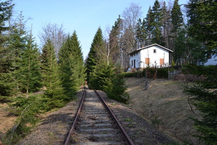
Reitzenhain station was border station on the Saxon line Flöha-Reitzenhain which continued via Reizenhain (Pohraniční) to Komotau (Chomutov). When cross-border traffic ceased after World War II, the station lost its importance. Passenger trains to Reitzenhain were cancelled on 1 October 1978, freight trains on 8 January 1994, the line between Marienberg and Reitzenhain was closed on 15 December 1998 and has been lifted in 2013 in favour of a bicycle and hiking path.
Reitzenhain has bus connections with Annaberg-Buchholz, Marienberg and Olbernhau on weekdays, and to Rübenau and Satzung on schooldays, provided by VMS.