
Region Tujetsch, Graubünden Mouth Lai da Curnera | River system Rhine Country Switzerland | |
 | ||
Main source Maighels Glacier
2,590 m (8,500 ft) River mouth Into the Lai da Curnera
1,950 m (6,400 ft) Progression Rein da Curnera → Vorderrhein → Rhine → North Sea | ||
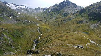
Armonia del rein da maighels nascente
The Rein da Maighels (German: Maighelserrhein) is one of the main tributaries of the Rhine (see Sources of the Rhine) and is a tributary to the Rein da Curnera. The firm Kraftwerke Vorderrhein AG has built a hydropower dam creating a reservoir, called the Lai da Curnera, into which both rivers now flow.
Contents
Map of Rein da Maighels, Tujetsch, Switzerland
The origin of the Rein da Maighels is the Maghels Glacier (Romansh: Glatscher da Maighels) on the Piz Ravetsch near the point where the cantons of Graubünden, Ticino and Uri meet. From the glacier, the Rein da Maighels flows north, through the Val da Maighels, then east, through Val Platta' between Piz Cavradi and Piz Piogn Crap, then into Val Curnera and into the Lai da Curnera reservoir.
References
Rein da Maighels Wikipedia(Text) CC BY-SA