Supriya Ghosh (Editor)

Rehberg (Wasgau)

Updated on
Edit
Like
Comment
Share on FacebookTweet on TwitterShare on LinkedInShare on Reddit
Elevation
  
577 m

Rehberg (Wasgau) httpsuploadwikimediaorgwikipediacommonsthu

Prominence
  
320.6 m ↓ Basin northwest of Hauenstein, junction of L 495 with the B 10 (256.2 m)

Isolation
  
7 km → Orensberg (581.2 m)

Parent range
  
Wasgau → Palatine Forest

Age of rock
  
251–243 MYA (Bunter sandstone), 256–251 MYA (Zechstein)

Mountain type
  
Rock units: Bunter sandstone and Zechstein conical hill/ridge

Similar
  
Asselstein, Anebos Castle, Rehbergturm, Scharfenberg Castle, Trifels Castle

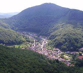
The Rehberg is a prominent hill, 576.8 m above sea level (NHN), in the German state of Rhineland-Palatinate. After the Grand Wintersberg (ca. 581 m) in French North Alsace, the Rehberg is the second highest hill in the Wasgau (French: Vasgovie), the Franco-German region that forms the southern part of the Palatine Forest and runs from the valley of the River Queich to the Col de Saverne . The Rehberg is also the highest hill on German soil in the Wasgau. As part of the Palatine Forest-North Vosges Biosphere Reserve it has been placed under special protection measures.

Contents

Map of Reh-Berg, 76857 Waldrohrbach, Germany

It lies two kilometres south of the town of Annweiler and has an observation tower at the summit named the Rehberg tower after the hill. The tower offers visitors an unhindered panoramic view over large parts of the Palatine Forest and Upper Rhine Plain as far as the hill chains of the Odenwald, Black Forest and Vosges.

LiteratureEdit

  • Deutscher Wetterdienst, ed. (1957) (in German), Klima-Atlas von Rheinland-Pfalz, Bad Kissingen: Verlag Deutscher Wetterdienst, ISBN 3881481354 
  • Michael Geiger et al., ed. (1987) (in German), Der Pfälzerwald, Porträt einer Landschaft, Landau/Pfalz: Verlag Pfälzische Landeskunde, pp. 21–46, ISBN 3980114716 
  • Michael Geiger (1990), Adolf Hanle, ed., "Rehberg" (in German), Pfälzerwald und Weinstraße (Mannheim: Meyers Lexikonverlag): pp. 106–107, ISBN 3411071311 
  • Michael Geiger (2010), Michael Geiger et al., ed., "Die Landschaften der Pfalz" (in German), Geographie der Pfalz (Landau/Pfalz: Verlag Pfälzische Landeskunde): pp. 98–101, ISBN 9783981297409 
  • Jost Haneke; Michael Weidenfeller (2010), Michael Geiger et al., ed., "Die geologischen Baueinheiten der Pfalz" (in German), Geographie der Pfalz (Landau/Pfalz: Verlag Pfälzische Landeskunde): pp. 74–91, ISBN 9783981297409 
  • Adolf Hanle (1990) (in German), Meyers Naturführer, Pfälzerwald und Weinstraße, Mannheim: Bibliographisches Institut, pp. 7–12, ISBN 3411071311 
  • Landesamt für Geologie und Bergbau Rheinland-Pfalz, ed. (2003) (in German), Geologische Übersichtskarte von Rheinland-Pfalz 1:300,000, Mainz 
  • Edmund Mainberger (1987), Michael Geiger et al., ed., "Der Wald" (in German), Der Pfälzerwald, Porträt einer Landschaft (Landau/Pfalz: Verlag Pfälzische Landeskunde): pp. 101–126, ISBN 3980114716 
  • References

    Rehberg (Wasgau) Wikipedia