
Existed: 2015 – present Length 60 km | Southeast end: Hwy 46 Constructed 2015 | |
 | ||
Northwest end: Hwy 11 (Louis Riel Trail) | ||
Regina bypass october 2016 update final
The Regina Bypass is a four-lane twinned highway connector road linking two National Highway System routes in Regina, Saskatchewan. Highway 1 (the Trans-Canada Highway) and Highway 11 will be linked by this new route, forming a partial ring road around the city.
Contents
- Regina bypass october 2016 update final
- Map of Pinkie Rd Sherwood No 159 SK Canada
- Regina bypass balgonie to highway 33
- Route description
- History
- Intermodal facility
- Environmental and heritage impact
- Intersections south to north
- References
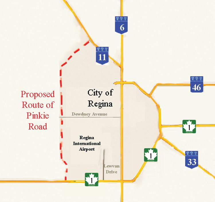
Map of Pinkie Rd, Sherwood No. 159, SK, Canada
The route will replace the city's existing Ring Road as the primary urban bypass route around the city. Although originally also constructed as a bypass route around the city's urban core for through traffic, the city's urban growth since Ring Road's construction has effectively turned it into an arterial road with high traffic congestion along some portions of the route.
Construction on all three phases began in 2015 or 2016. Some portions of the route are slated for completion and opening in 2017, with the entire route slated to be complete in 2019. As of December 2016, construction on the bypass route was 40 per cent complete.
The project, slated to cost $1.8 billion overall, is the largest single infrastructure project in the history of Saskatchewan.
Regina bypass balgonie to highway 33
Route description
The project is being built in three distinct sections: "Area 1", which will upgrade and extend the city's existing Pinkie Road into a full connection between Highway 1 and Highway 11 in the west of the city; "Area 2", which will construct a new route south of the city between Highway 1 and Highway 33; and "Area 3", which will complete the connection from Highway 33 back to Highway 1 in the east of the city adjacent to Tower Road, as well as further upgrades to the existing route of Highway 1 easterly to Highway 46.
The route will run west of the Regina International Airport.
History
Plans for the Pinkie Road segment of the route were announced in 2009, with the remainder of the bypass loop finalized in 2014.
Pinkie Road will be a primary access highway with access points for the Global Transportation Hub (GTH). The project is undertaken by the City of Regina, Sherwood No. 159 rural municipality (RM) Ministry of Highways and Infrastructure (MHI) and Transport Canada to provide an Intermodal freight transport center and the road infrastructure between two National Highway System routes. C$27 million will be contributed by the Government of Canada as part of the Asia-Pacific Gateway and Corridor Initiative (APGCI) towards this $93 million project. The provincial government will commit about $27 million to the project. Former Highways and Infrastructure Minister Wayne Elhard discussed expanding the Government's role in the next phase of the development project. The average vehicles per day (vpd) on both Hwy 1 and Hwy 11 were examined in 5 year, and 25 year projections. The traffic on Hwy 1 is expected to have an average of 10,140 / 11,210 vpd on the west and east side of the proposed interchange in five years. This amount in 25 years is expected to increase to 21,040 vpd on the west and 31, 340 vpd on the east side of the proposed interchange respectively. Hwy 11 is projected to increase from 13,060 to 23870 vpd in 25 years.
The new connector road across Dewdney Avenue will carry 5,500 vpd projected in 5 years increasing to 33,000 vpd in 25 years. Currently the Average Annual Daily Traffic (AADT) on Hwy 1 is 9,280 vpd west of Pinkie Road, and 11,680 on the east side of Pinkie Road. On Hwy 11 east of the interchange the AADT is 8,840. On Pinkie Road south of the interchange the traffic volume is 7,740 vpd. John Law, deputy minister of Highways and Infrastructure estimated that it will cost about $45 million to upgrade service roads to Pinkie Road and the intermodal facility to support approximately 1,400 commercial trucks per week in the area. The current proposal is looking at a 4 lane twinned highway with service roads. It will become part of the long term bypass route around Regina, and will accommodate future growth of the city to a population of 300,000. Pinkie Road will be approximately 26 kilometres (16 mi) in length. The annexation of land by the city from the RM of Sherwood is being negotiated and the city will pay about $1,500,000 and supply water to the RM for the land segment.
The city initially considered four industrial land options for development Argyle Park - IPSCO lands, Regina Airport, Ross Industrial Park and the Pinkie Road and Trans-Canada Highway areas. In November 2007, Regina City Council examined a report which studied projected industrial growth for the city of Regina until 2027. The study proposed a new industrial area west of the Regina airport. The major roads would be constructed by the Ministry of Highways and Infrastructure and they would be supported by a $7 million payment by the City of Regina. The city also examined at this concept plan the cost of $54 million for infrastructure servicing of facilities. Regina's general manager of corporate services is looking at servicing fees and development levies to help repay the loan. A 20 year time frame will extend land use to also include a light industrial park. A number of open houses were held with the public to determine planning, road alignments, access points and general location of the new connector road. Following the advisement of two consultation firms the City of Regina has determined to proceed with the land development and water, drainage, and wastewater management procedures outlined for the Regina Inland Port. There will be two phases of land development the land development west of Pinkie Road will constitute phase 1 and east of Pinkie Road will be Phase 2.
Intermodal facility
The Canadian Pacific Railway (CPR) intermodal facility (IMF) currently located in Regina's downtown will be re-located west of the city which will enable the CPR to expand its facilities at a new location enabling a more efficient staging of trains. The Regina Regional Economic Development Authority RREDA has worked on establishing Regina as a transportation hub, and this inland port brings together air, road and rail travel services for the export and import of goods. The CPR IMF will be joined by Loblaws Company Limited $200-million western Canadian distribution facility. The multimodal hub will encourage North American trade and world distribution, transportation, imports and exports.
Environmental and heritage impact
The proposal is studying the impact the new roadway will have on protected species of fauna in Saskatchewan such as the burrowing owl (Athene cunicularia), loggerhead shrike (Lanius ludovicianus), Sprague's pipit {Anthus spragueii}, peregrine falcon (Falco peregrinus), yellow rail (Coturnicops noveboracensis), monarch butterfly (Danaus plexippus) and northern leopard frog (Rana pipiens). Flora of Saskatchewan which may be impacted would be the prairie ragwort (Senecio plattensis) and Geyer's onion (Allium geyeri). The Presbyterian Indian Residential School Cemetery is also located in this vicinity north of Dewdney Avenue and east of Pinkie Road. The project is being planned to meet any requirements set forth under the Building Canada Plan as well as evaluation of project procedures for environmental concerns as set out by the Canadian Environmental Assessment Act.
Intersections south to north
Length is approximate based on local roads currently existing.