
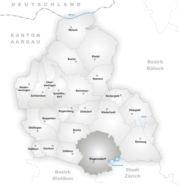
Country Elevation 443 m Population 16,518 (Dec 31, 2010) Area 14.62 km2 | District Dielsdorf | |
Regensdorf is a municipality in the district of Dielsdorf of the canton of Zurich in Switzerland. It is the biggest city in the region Furttal (ZH).
Contents
- Map of Regensdorf
- Demographics
- Transportation
- Thomas ronner f6b aeromusical regensdorf 2014
- History
- Geography
- References
Map of Regensdorf
Katzensee is a lake on the border with the Affoltern quarter of the city of Zurich.
Demographics
Regensdorf has a population (as of 31 December 2013) of 17,132. As of 2007, 31.4% of the population was made up of foreign nationals. Over the last 10 years the population has grown at a rate of 16.5%. Most of the population (as of 2000) speaks German (77.8%), with Italian being second most common ( 5.6%) and Albanian being third ( 3.9%).
In the 2007 election the most popular party was the SVP which received 48.2% of the vote. The next three most popular parties were the SPS (16.5%), the FDP (9.5%) and the CVP (8.7%).
The age distribution of the population (as of 2000) is children and teenagers (0–19 years old) make up 21.7% of the population, while adults (20–64 years old) make up 67.7% and seniors (over 64 years old) make up 10.6%. In Regensdorf about 65.6% of the population (between age 25-64) have completed either non-mandatory upper secondary education or additional higher education (either university or a Fachhochschule).
Regensdorf has an unemployment rate of 3.39%. As of 2005, there were 97 people employed in the primary economic sector and about 30 businesses involved in this sector. 2418 people are employed in the secondary sector and there are 163 businesses in this sector. 6321 people are employed in the tertiary sector, with 626 businesses in this sector.
The historical population is given in the following table:
Transportation
Regensdorf-Watt railway station is a stop of the S-Bahn Zurich on the line S6. Regensdorf can be reached from Zurich with train (s-bahn) S6. There is a train every half an hour.
Upon the completion of the 4th development phase of Zurich S-Bahn network, S21 will be added to serve the line Regensdorf-Zurich. According to ZVV, S21 will go through the new DML tunnel and it wont be stopping at Zurich-Seebach.
In September 2014 an additional Zurich S-Bahn connection from Regensdorf to Zurich Main Station via ETH Honggerberg "Science City" underground station has been published. [1].
Thomas ronner f6b aeromusical regensdorf 2014
History
Regensdorf is first mentioned in 870 as Reganesdorf. In 931 it was mentioned as Wat and in 1040 as Adalinchova.
Geography
Regensdorf has an area of 14.6 km2 (5.6 sq mi). Of this area, 43.5% is used for agricultural purposes, while 23.6% is forested. Of the rest of the land, 30.6% is settled (buildings or roads) and the remainder (2.3%) is non-productive (rivers, glaciers or mountains).
The municipality is located on both sides of the Furtbach (Furt stream). It consists of the villages of Watt (which in turn includes the hamlets of Oberdorf, Altburg, Katzensee and Neu-Hard), Adlikon and Regensdorg (which includes the hamlets of Alt-Hard and Geissberg).