
Primary inflows Basin countries United States Max. width 2.7 km (1.7 mi) Area 247 ha Length 4.81 km Outflow location Black Creek | Primary outflows Black Creek Max. length 4.81 km (2.99 mi) Surface area 611 acres (247 ha) Surface elevation 2,179 m Width 2.7 km Inflow source Black Creek | |
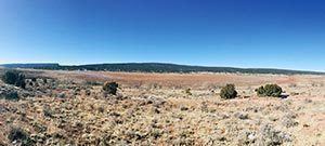 | ||
Red Lake is a lake located next to Navajo, New Mexico, in the Red Valley in McKinley County, New Mexico and Apache County, Arizona. The lake has a surface elevation of 7,150 ft (2,180 m). Navajo, New Mexico, lies on the southeast corner of the lake.
Contents
Map of Red Lake, 87328, USA
DescriptionEdit
Red Lake is a small lake, only 3 miles (5 km) long, and only half as wide. It is mostly north-south and is bordered on the east by Reservation Route 12, a north stretch from Window Rock, Arizona to Navajo, New Mexico.
Red Lake is located on the eastern border of the long north-south Defiance Plateau, where Canyon de Chelly comprises its north, and the Chuska Mountains border to the northeast. Only the western fourth of the lake is in Arizona, and Red Lake is on the southwest foothills of the Chuska's with the beginning of Black Creek and other creeks and washes as inflows to the lake. From Red Lake, Black Creek flows due south on the central and southeast border of the Defiance Plateau. The north-south stretch of Black Creek, in Arizona, parallels the western border of New Mexico.
Black Creek then turns southwest to meet the Puerco River, just southeast of Houck, southwest of Allentown, both on Interstate 40. The interstate follows the north side of the Puerco River in this stretch.