
Admin. region Stuttgart Elevation 339 m (1,112 ft) Area 6.4 km² Population 5,387 (31 Dec 2008) Dialling code 07161 | Time zone CET/CEST (UTC+1/+2) Local time Sunday 1:52 AM Postal code 73098 Administrative region Stuttgart | |
 | ||
Weather 7°C, Wind E at 14 km/h, 60% Humidity | ||
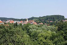
Rechberghausen is a town in the district of Göppingen in Baden-Württemberg in southern Germany.
Contents
- Map of Rechberghausen Germany
- Geographical location
- Neighbouring communities
- History
- Religions
- Inhabitants
- Mayor
- References
Map of Rechberghausen, Germany
Geographical location
The community lies in on the foothills of the central Swabian Jura and on the edge of the eastern Schurwald. The hight is 320 to .
Neighbouring communities
In the northwest the municipality borders to Börtlingen, in the northeast to Birenbach. Eastern and south-eastern neighbour is the county seat Göppingen, with its Bartenbach district, the western neighbour is the community Wangen (Göppingen). All are located in the district of Göppingen.
History
The place was first mentioned in 1245. He was then the Dukes of Teck after the local castle had previously probably heard the Lords of Rechberghausen.
Religions
Till the seventies of the 20th century, the Catholics had a great majority. Today there is a very active evangelical community. The Catholic Church Mariä Himmelfahrt was consecrated in 1912, the evangelic Jesus Christus Kirche in 1961.
Inhabitants
The development between 1837 and 2010.
Source: Statistical Office Stuttgart
Mayor
Mayor was from December1, 1977 to June 30, 2015 Reiner Johannes Ruf. Since July 1, 2015 Claudia Dörner is the new mayor in Rechberghausen.