
Country India District South Sikkim Vehicle registration SK | State Sikkim Time zone IST (UTC+5:30) Local time Saturday 11:43 AM | |
 | ||
Weather 15°C, Wind SW at 8 km/h, 66% Humidity | ||
Ravangla hd chinu
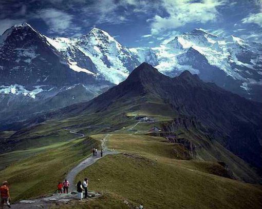
Ravangla or Rawangla or Ravongla is a small tourist town situated at an elevation of 7000 ft in South Sikkim district of the Indian state of Sikkim. It is connected by state highway to other major towns in the state and lies between Pelling and Gangtok. It acts as the starting point for the trek to Maenam Wildlife Sanctuary.
Contents
- Ravangla hd chinu
- Map of Ravangla Sikkim 737139
- Organic vegetable market in rainy ravangla sikkim
- Geographical situation
- Flora
- Avifauna
- Tibetan community
- Education
- References
Map of Ravangla, Sikkim 737139
Organic vegetable market in rainy ravangla sikkim
Geographical situation
Mt. Kanchenjunga, Mt. Pandim, Mt. Siniolchu, Mt. Kabru are just a few of the major peaks that are clearly visible from Ravangla.
Flora
Upper parts of Ravangla experiences snowfall during winter. During the months of April–May the place is surrounded by many flowers including orchids and rhododendrons.
Avifauna
Ravangla attracts a lot of Himalayan birds and is a bird watcher's paradise. Birds like verditer flycatchers, blue-fronted redstarts, grey bushchats, dark-throated thrush, blue whistling-thrush, green-backed tit and white-browed fantails can be easily spotted.
The forests around Ravangla have other birds like laughingthrushes, babblers, cuckoos and hill partridges. The rare satyr tragopan can also be spotted in Ravangla.
Tibetan community
Ralang Monastery, a Buddhist monastery of the Kagyu school of Tibetan Buddhism is located six kilometres from Ravangla.
Education
National Institute of Technology Sikkim, established in 2011 has its temporary campus in this picturesque town.