
 | ||
Similar Colorado National Monument, Children's Nature Center, Museums of Western Colorado, Adventurous Antelope Canyon, Rim Rock Drive | ||
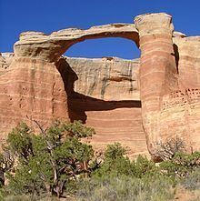
Rattlesnake Canyon is a scenic area within the Black Ridge Canyons Wilderness which in turn forms the core of the Bureau of Land Management administered McInnis Canyons National Conservation Area in west central Colorado. The canyon contains nine natural arches, the second highest concentration of such arches in the United States, after the much better known Arches National Park.
Contents
Map of Rattlesnake Canyon, Colorado 81521, USA
Access to the canyon is either by a strenuous seven mile hike from the Pollack Bench trailhead or by the Black Ridge access roads. The latter are reached via the adjacent Colorado National Monument. These dirt roads are open seasonally and should only be attempted in a high ground clearance four wheel drive vehicle under dry conditions due to steep, rocky grades.
The arches loop trail descends and then circumnavigates a bench into the canyon. It passes six arches before arriving at Cedar Tree Arch. A slightly tricky ascent on steep sandstone slopes and moqui steps leads to the top of the canyon and a trail spur that completes the circuit.